Oklahoma City Maps and Orientation
(Oklahoma City, Oklahoma - OK, USA)
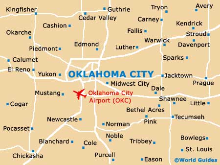
Oklahoma City resides within the heart of the state of Oklahoma, serving as both the state's biggest city and the capital. The city and its boundaries include the counties of Canadian, Cleveland and also Pottawatomie, as well as Oklahoma County, where it is the county seat.
The Metropolitan Area covers an enormous region of some 6,360 square miles / 16,470 square kilometers. The main towns and cities located within the Oklahoma City Metropolitan Area include those of Bethany, Chandler, Chickasha, Choctaw, Del City, Edmond, El Reno, Guthrie, Jones, Kingfisher, Midwest City, Moore, Mustang, Norman, Piedmont, Shawnee and Yukon.
Various busy highways intersect the city, such as Interstate I-35 (Route 77 / Highway 77) and Interstate I-44 (HE Bailey Turnpike 62), both of which head in a north to south direction. Running east to west is Interstate I-40 (US-270) and Interstate I-240 (Southwest Expressway).
Maps and Orientation of the City
The city is made up of various districts, such as downtown and neighboring Bricktown, to the east, where a series of historic warehouses have been converted into trendy bars, eateries and nightspots. This is also where you will find the Bricktown Ballpark.
Further city neighborhoods include the Adventure District, home to the National Cowboy and Western Heritage Museum. The Paseo Arts District is known for its plentiful galleries and cultural attractions, as is the NW 39th Street Enclave and the aptly named downtown Arts District, which is where the Oklahoma City National Memorial resides, along with the Oklahoma City Art Museum (OKCMOA).
For city maps, pay a visit to the Oklahoma City Visitors Center, which is located on Park Avenue, close to the Chase Tower and the First National Center, and just a couple of blocks away from the Myriad Botanical Gardens.
- Bethany - 12 miles / 19 km (20 minutes, west)
- Del City - 6 miles / 10 km (12 minutes, east)
- Edmond - 14 miles / 23 km (25 minutes, north)
- El Reno - 28 miles / 45 km (45 minutes, west)
- Glenbrook - 7 miles / 11 km (15 minutes, north)
- Lake Ridge - 12 miles / 19 km (20 minutes, southwest)
- Lake Stanley Draper - 16 miles / 26 km (25 minutes, southeast)
- Lake Thunderbird State Park - 30 miles / 48 km (50 minutes, southeast)
- Meadowcreek - 12 miles / 19 km (20 minutes, north)
- Midwest City - 8 miles / 13 km (15 minutes, east)
- Moore - 11 miles / 18 km (20 minutes, south)
- Mustang - 17 miles / 27 km (30 minutes, southwest)
- Norman - 19 miles / 31 km (30 minutes, south)
- Northwood Lake Estates - 27 miles / 43 km (45 minutes, northwest)
- Piedmont - 21 miles / 34 km (35 minutes, northwest)
- Spencer - 11 miles / 18 km (20 minutes, northeast)
- Stinchcomb Wildlife Refuge - 15 miles / 24 km (25 minutes, northwest)
- Yukon - 16 miles / 26 km (25 minutes, northwest)
Map of the United States

Map of Oklahoma
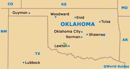
Map of Oklahoma City