Saint Louis Maps and Orientation
(Saint Louis, Missouri - MO, USA)
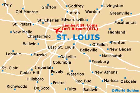
Famous for its iconic Gateway Arch, the city of Saint Louis is located on the far eastern side of Missouri, being especially close to the state border with
Illinois. The state's second-biggest city, Saint Louis does not actually belong to a county as such, instead being classed as an independent city.
As the city expanded over the years, planners were always very conscious to ensure that plenty of green spaces and public parks would be in place for recreational purposes. Around downtown Saint Louis, the most notable include the Kiener Plaza, the Gateway Mall, Kaufman Park, Poelker Park, Washington Square Park, the Eternal Flame Park and the Memorial Plaza, amongst others.
The Mississippi River divides the city into two main regions, east and west. Downtown Saint Louis resides on the western side of the Mississippi, while East Saint Louis stands on the eastern banks, being connected by the Poplar Street Bridge (Interstate I-55), the Eads Bridge and also the Martin Luther King Bridge.
Maps and Orientation of the City
Tourists will find the most interesting neighborhoods radiating outwards from the heart of downtown Saint Louis, such as Central West End, the Hill, Lafayette Square, the Loop, Soulard and also South Grand.
For maps and tourist information, the Missouri Welcome Center on Interstate I-270 (exit 34) is worth looking out for.
- Alton - 22 miles / 35 km (40 minutes, north)
- Belleville - 18 miles / 29 km (30 minutes, southeast)
- Chesterfield - 22 miles / 35 km (40 minutes, west)
- Fairview Heights - 15 miles / 24 km (25 minutes, east)
- Florissant - 18 miles / 29 km (30 minutes, northwest)
- Granite City - 8 miles / 13 km (15 minutes, north)
- Hazelwood - 17 miles / 27 km (30 minutes, northwest)
- Jennings - 9 miles / 14 km (15 minutes, north)
- Kirkwood - 15 miles / 24 km (25 minutes, southwest)
- Lemay - 9 miles / 14 km (15 minutes, south)
- Maryland Heights - 18 miles / 29 km (30 minutes, northwest)
- Mehlville - 13 miles / 21 km (25 minutes, south)
- Oakville - 13 miles / 21 km (25 minutes, south)
- Pontoon Beach - 14 miles / 23 km (25 minutes, northeast)
- Spanish Lake - 13 miles / 21 km (25 minutes, north)
Map of the United States

Map of Missouri

Map of Saint Louis