Topeka Maps and Orientation
(Topeka, Kansas - KS, USA)
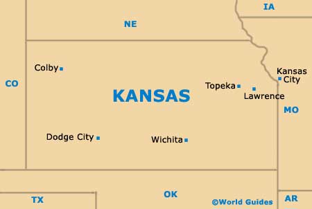
The state of Kansas sits in the very heart of North America, with Topeka serving as its historic capital city. Located in the northeastern quadrant of Kansas, Topeka is actually one of the least centrally located state capitals in the whole of the United States.
The city also functions as the county seat for Shawnee County and has a relatively modest population for a state capital, being called home by approximately 130,000 residents. This actually makes Topeka only the third-largest city in Kansas, after
Wichita (roughly 400,000) and Overland Park (almost 180,000).
Topeka was both founded and incorporated in the middle of the 19th century, growing up on the southern bank of the Kansas River. The city's spreading metropolitan area features a population fast approaching 250,000 and this region also comprises the counties of Jackson, Jefferson, Osage, Shawnee and Wabaunsee.
Maps and Orientation of the City
Being the state capital means that Topeka is well connected to the rest of Kansas and it is easy to find your way around using maps. The city resides at the intersection of Highway US-75 and Interstate I-70, being the location where Interstate I-335 originates (the Kansas Turnpike to Emporia). Both Highway US-24 and Highway US-40 pass through the city.
The Old Town area of Topeka city center holds much interest for visitors to the city and is where you will find the Kansas State Capitol Building. Several green spaces and parks lie next to the Capitol, such as Plaza Park and Huntoon Park, while a few blocks to the southeast is the Brown v Board of Education National Historic Site, in Cushinberry Park.
- Atchison - northeast
- Emporia - southwest
- Gardner - southeast
- Junction City - west
- Kansas City, Missouri (MO) - east
- Lansing - northeast
- Lawrence - east
- Leavenworth - northeast
- Manhattan - west
- Merriam - east
- Olathe - east
- Overland Park - east
- Ottawa - southeast
- Shawnee - east
- Wichita - southwest
Map of USA
Map of Kansas
Map of Topeka
