Miami Maps and Orientation
(Miami, Florida - FL, USA)
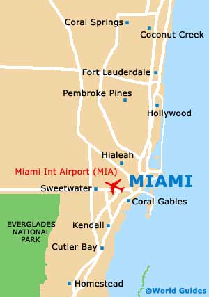
Situated next to the Atlantic coastline and on the southern side of Florida, Miami lies just to the south of Fort Lauderdale and within Miami-Dade County, where it is the county seat.
The city belongs to the expansive Miami Metropolitan Area, which boasts an overall population now exceeding 5.5 million and also incorporates a number of additional cities, including Boca Raton, Fort Lauderdale, Hialeah, Pompano Beach and West Palm Beach.
Visitors will find that the main area of the city is located next to Biscayne Bay, where a huge number of barrier islands are located, man-made and natural, big and small. The largest of these barrier islands is where you will find South Beach (SoBe) and Miami Beach, the latter of which is considered to be an independent coastal resort city. Miami Beach is separated from the main city by Biscayne Bay, although is easy to reach via the Julia Tuttle Causeway (Interstate I-195 / Florida State Road SR-112).
Maps and Orientation of the City
Notable districts around Miami include those of Coral Gables, Coconut Grove, Little Havana and also Little Haiti. All of these hold plenty of appeal for tourists, being well connected to the grid-system of downtown Miami.
If you are planning to self-drive around this part of Florida, then maps can be obtained from most car rental outlets. You can also pick up maps from the Greater Miami, Beaches Convention and Visitors Bureau on Brickell Avenue, and from the Miami Beach Chamber of Commerce (Visitor Center), which is located on Meridian Avenue, next to the Botanical Garden and the Holocaust Memorial.
- Boca Raton - 46 miles / 74 km (one hour and ten minutes, north)
- Coral Gables - 7 miles / 11 km (15 minutes, south)
- Coral Springs - 42 miles / 68 km (one hour, north)
- Cutler Bay - 21 miles / 34 km (30 minutes, south)
- Delray Beach - 52 miles / 84 km (one hour and 20 minutes, north)
- Fort Lauderdale - 28 miles / 45 km (40 minutes, north)
- Fort Myers - 156 miles / 251 km (three hours, northwest)
- Hialeah - 8 miles / 13 km (20 minutes, north)
- Homestead - 33 miles / 53 km (45 minutes, southwest)
- Kendall - 16 miles / 26 km (25 minutes, south)
- Key West - 160 miles / 257 km (four hours, southwest)
- Miami Gardens - 15 miles / 24 km (25 minutes, north)
- Naples - 125 miles / 201 km (two hours and 45 minutes, northwest)
- Pembroke Pines - 23 miles / 37 km (35 minutes, northwest)
- Pompano Beach - 35 miles / 56 km (50 minutes, north)
- South Miami Heights - 20 miles / 32 km (30 minutes, southwest)
- Taramac - 34 miles / 55 km (50 minutes, north)
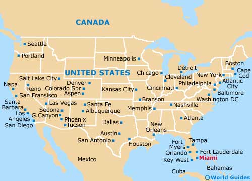
Map of the United States
Map of Florida

Map of Miami