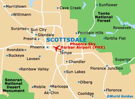
Scottsdale Maps and Orientation
(Scottsdale, Arizona - AZ, USA)
Located on the southern side of central Arizona, the sunny city of Scottsdale stands within Maricopa County, where it is especially close to
Phoenix. In fact, Scottsdale actually resides within the Phoenix Metropolitan Area (the Valley of the Sun).
Also close by are the small towns and cities of Carefree, Fountain Hills,
Mesa, Paradise Valley and Tempe, while both the Phoenix Mountains Preserve and the Piestewa Peak Park can be found roughly 20 minutes to the northwest, next to the Tatum Canyon neighborhood.
Most tourists paying a visit to Scottsdale choose to take a stroll around the historic Old Town, where an assortment of shops and attractive buildings from the early 20th century await, along with plenty of eateries and galleries.
Maps and Orientation of the City
Many people basing themselves in this part of Arizona plan to get out and about in a rental car, paying a visit to neighboring attractions such as the Casa Grande Ruins National Monument at Coolidge.
If you feel the need for maps, then check out the bookstores on the North Goldwater Boulevard and East 2nd Street, as well as the Visitors Bureau on North Scottsdale Road, which stands next to the North Drinkwater Boulevard and East Stefson Drive.
- Apache Junction - 32 miles / 51 km (50 minutes, east)
- Casa Grande - 53 miles / 85 km (one hour and 20 minutes, south)
- Chandler - 19 miles / 31 km (35 minutes, southeast)
- Coolidge - 60 miles / 97 km (one hour and 30 minutes, southeast)
- Flagstaff - 155 miles / 249 km (three hours and 45 minutes, north)
- Fountain Hills - 21 miles / 34 km (35 minutes, northeast)
- Gilbert - 18 miles / 29 km (30 minutes, southeast)
- Glendale - 21 miles / 34 km (35 minutes, west)
- Gold Canyon - 37 miles / 60 km (one hour, southeast)
- Maricopa - 40 miles / 64 km (one hour, south)
- Mesa - 12 miles / 19 km (20 minutes, southeast)
- Phoenix - 12 miles / 19 km (20 minutes, southwest)
- Prescott - 109 miles / 175 km (two hours and 30 minutes, north)
- Queen Creek - 34 miles / 55 km (55 minutes, southeast)
- Sedona - 125 miles / 201 km (three hours, north)
- Sun Lakes - 25 miles / 40 km (40 minutes, south)
- Tempe - 6 miles / 10 km (12 minutes, south)
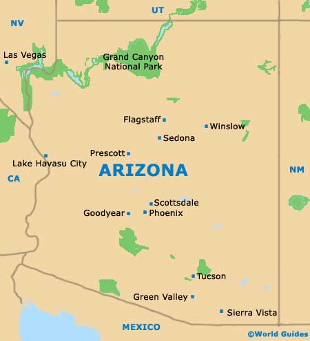
Map of the United States

Map of Arizona
Map of Scottsdale