Cayo Guillermo Maps and Orientation
(Cayo Guillermo, Ciego de Avila, Jardines del Rey, Cuba)
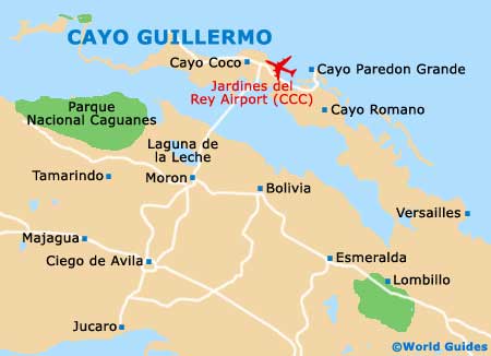
The connected islands of Cayo Guillermo and Cayo Coco are both part of the Archipélago de Sabana-Camagüey, which runs for 300 km / 186 miles along the northern coast of
Cuba. There are more than 400 islands and cays here, but only Cayo Guillermo and Cayo Coco have any real development. This will surely change, however, as the Cuban government has serious plans to develop other cays in the archipelago.
It is unlikely that you will need a map to find your way around the cays. But if you do, all of the resorts offer an easy-to-read map outlining the natural preserves, beaches and other hotels. There is basically one road winding along the coast, so it is a snap to get around.
Maps and Orientation of the Island
Despite being called cays, Cayo Guillermo and Cayo Coco are both deceptively large. Walking isn't an option, unless you are just strolling down the beach to a neighbouring resort. The ideal way to explore the islands is on a scooter. Most of the resorts rent them, or bicycles if you prefer to move under your own power.
A tourist bus called Jardines del Rey Bus Tour runs the entire loop from the end of Playa Coco to Playa Guillermo. There are also taxis on the island that can be called for a pickup, or you rent your own vehicle from a car hire firm stationed within your resort. As all of the resorts are self-contained entities, they offer a number of organised excursions to take guests from one beach to the other. You'll have no trouble sorting out the transport details right in the lobby of your hotel.
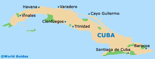
- Camaguey - 202 km / 126 miles (three hours, south-east)
- Ciego de Avila - 98 km / 61 miles (two hours, south)
- Havana - 550 km / 342 miles (six hours, west)
- Morón - 27 km / 17 miles (30 minutes, south)
- Trinidad - 270 km / 168 miles (four hours, south-west)
Map of Cuba
Map of Cayo Guillermo