Wroclaw Maps and Orientation
(Wroclaw, Silesia, Poland)
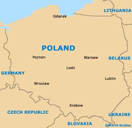
Sited on the south-western side of
Poland and within the historic Lower Silesia region, Wroclaw is the country's fourth-biggest city, with a population soon to reach 700,000 people. Wroclaw is the regional capital of Lower Silesia and is based around the Oder River.
Wroclaw comprises five main districts, which include the industrial and commercial borough of Fabryczna, along with Krzyki and also Psie Pole, the latter of which is an extremely green suburb of the city, with good transport links to
Warsaw. Psie Pole is a particularly historic location in Wroclaw, where a battle between
Germany and Poland took place at the beginning of the 12th century.
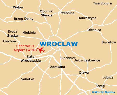
Maps and Orientation of the City
For tourists visiting Wroclaw, the districts of most interest are the city centre itself (Sródmiescie), and the oval-shaped Old Town area, known locally in Polish as the Stare Miasto and surrounded by a ring road. The majority of all the main sights in Wroclaw are within a stroll of these central boroughs.
For maps of the city, head to the Old Market Square (Rynek), where both the Wroclaw Tourist Office and the Cultural Information Centre (Osrodek Kultury i Sztuki) reside.
- Dresden (Germany) - 267 km / 166 miles (three hours and 20 minutes, west)
- Glogów - 109 km / 68 miles (one hour and 40 minutes, north-west)
- Jelenia Góra - 114 km / 71 miles (one hour and 45 minutes, west)
- Kalisz - 119 km / 74 miles (one hour and 50 minutes, north-east)
- Krakow - 272 km / 169 miles (three hours and 30 minutes, south-east)
- Legnica - 78 km / 48 miles (one hour, west)
- Lodz - 208 km / 129 miles (three hours, north-east)
- Lubin - 73 km / 45 miles (one hour, north-west)
- Opole - 97 km / 60 miles (one hour and 20 minutes, south-east)
- Ostrów Wielkopolski - 95 km / 59 miles (one hour and 15 minutes, north-east)
- Poznan - 180 km / 112 miles (two hours and 40 minutes, north)
- Prague (Czech Republic) - 290 km / 180 miles (four hours, south-west)
- Rawicz - 65 km / 40 miles (one hour, north)
- Walbrzych - 82 km / 51 miles (one hour and 15 minutes, south-west)
- Warsaw - 341 km / 212 miles (four hours and 50 minutes, north-east)
Map of Poland
Map of Wroclaw