Montpellier Maps and Orientation
(Montpellier, Herault, Languedoc-Roussillon, France)
Directly west of
Marseille and to the north-east of both
Barcelona and
Girona, Montpellier lies around 10 km / 6 miles from the southern Mediterranean coast of France. Montpellier is located within the area known as Languedoc-Roussillon and has grown around the River Lez.
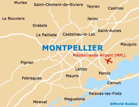
Within the city itself, many of the main places of interest are based around its highly pedestrianised centre, which is surrounded by a series of wide boulevards. The Place de la Comédie is based at the very heart of Montpellier and is often used as either a meeting point or a useful place of reference, being easily found on all maps of the city.
Maps and Orientation of the City
Situated on the north-easterly side of the Place de la Comédie, the Charles de Gaulle Esplanade is home to a significant market and this long tree-lined promenade is close to many hotels. Directly east, Montpellier's ever-popular Le Polygone shopping complex offers enough to keep you fully occupied for an entire day and the nearby Neo-classical Antigone housing project may also be of interest.
Head to the west and you will discover the Grand Rue Jean Moulin and also the Rue de la Loge. These two thoroughfares define the most historic quarter of Montpellier and are interconnected by a labyrinth of confusing narrow alleyways.
- Baillargues - 14 km / 9 miles (20 minutes, north-east)
- Cournonterral - 16 km / 10 miles (24 minutes, south-west)
- Fabrègues - 11 km / 7 miles (16 minutes, south-west)
- Grabels - 8 km / 5 miles (12 minutes, north-west)
- Lattes - 6 km / 4 miles (10 minutes, south)
- Le Cres - 8 km / 5 miles (12 minutes, north-east)
- Mauguio - 13 km / 8 miles (18 minutes, east)
- Nîmes - 51 km / 32 miles (45 minutes, north-east)
- Pignan - 11 km / 7 miles (16 minutes, west)
- Saint Gély Du Fesc - 13 km / 8 miles (18 minutes, north)
- Sète - 32 km / 20 miles (36 minutes, south-west)
- Villenueve Lès Maguelone - 11 km / 7 miles (16 minutes, south-west)
Map of France

Map of Montpellier