New Forest Maps and Orientation
(New Forest, Hampshire, England, UK)
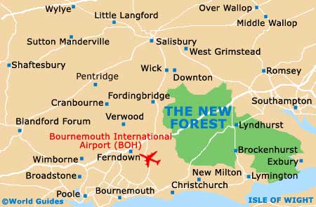
The New Forest is a truly beautiful part of Hampshire and lies in southern
England, close to the coastline and near to the counties of Dorset and Wiltshire. Now officially a National Park, the New Forest covers a vast area of approximately 150 square miles / 390 square kilometres, and is home to a series of charming villages, small towns and picture-postcard picnic spots.
Bournemouth and
Southampton stand on the very outskirts of the New Forest, being close to Holmsley and Ashurst respectively. If you are short of time, you can explore the area by car, although if you have more time, then the cycle trails and the pathways are the very best way to appreciate the wildlife and rolling countryside.
Maps and Orientation of the Area
Since the New Forest is such a large space, maps are recommended and widely available at the visitor information centres in the main towns, including both Lyndhurst and Lymington.
Destinations within the New Forest, from Lyndhurst
- Ashurst - 6 km / 4 miles (seven minutes, north-east)
- Beaulieu - 13 km / 8 miles (15 minutes, south-east)
- Blissford - 21 km / 13 miles (22 minutes, north-west)
- Bramshaw - 10 km / 6 miles (ten minutes, north)
- Brockenhurst - 6 km / 4 miles (seven minutes, south)
- Burley - 11 km / 7 miles (12 minutes, south-west)
- Cadnam - 6 km / 4 miles (seven minutes, north)
- Denny Lodge - 5 km / 3 miles (five minutes, east)
- Dibden Purlieu - 5 km / 3 miles (five minutes, east)
- East Boldre - 16 km / 10 miles (16 minutes, south-east)
- Emery Down - 8 km / 5 miles (eight minutes, west)
- Linford - 22 km / 14 miles (25 minutes, west)
- Linwood - 16 km / 10 miles (16 minutes, west)
- Minstead - 5 km / 3 miles (five minutes, north-west)
- Newbridge - 8 km / 5 miles (eight minutes, north)
- Newtown - 5 km / 3 miles (five minutes, north-west)
- Normansland - 13 km / 8 miles (15 minutes, north)
- South Gorley - 21 km / 13 miles (22 minutes, west)
- Stoney Cross - 8 km / 5 miles (eight minutes, north-west)
Destinations outside of the New Forest, from Lyndhurst
- Bishopstoke - 27 km / 17 miles (28 minutes, north-east)
- Bournemouth - 42 km / 26 miles (35 minutes, south-west)
- Christchurch - 24 km / 15 miles (25 minutes, south-west)
- Eastleigh - 26 km / 16 miles (28 minutes, north-east)
- Isle of Wight (Cowes - via ferry) - 37 km / 23 miles (one hour and 25 minutes, south-east)
- Locks Heath - 40 km / 25 miles (35 minutes, east)
- Marchwood - 13 km / 8 miles (15 minutes, east)
- Poole - 48 km / 30 miles (45 minutes, south-west)
- Portsmouth - 54 km / 34 miles (45 minutes, south-east)
- Ringwood - 22 km / 14 miles (25 minutes, west)
- Salisbury - 32 km / 20 miles (30 minutes, north-west)
- Southampton - 18 km / 11 miles (20 minutes, east)
- Swanage - 72 km / 45 miles (one hour and 15 minutes, south-west)
- Totton and Eling - 11 km / 7 miles (12 minutes, north-east)
- Verwood - 30 km / 19 miles (30 minutes, west)
- Weymouth - 88 km / 55 miles (one hour and 25 minutes, south-west)
Map of the United Kingdom

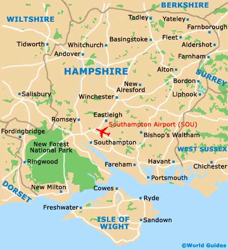
Map of Hampshire
Map of New Forest