Rijeka Maps and Orientation
(Rijeka, Primorje Gorski Kotar, Kvarner, Croatia)
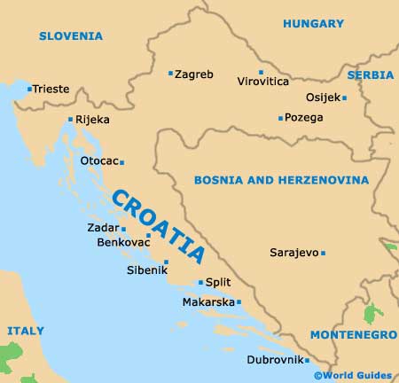
The city of Rijeka lies in the northernmost corner of
Croatia, on the spectacular Adriatic Sea inlet of Kvarner Bay, surrounded by mountain ranges and famous coastal holiday resorts. Rijeka's huge port is one of the largest in Croatia, while the city serves as a major rail and road transportation hub between eastern and northern Europe, with strong cultural ties with
Austria,
Hungary and
Italy.
Set in its own Rijeka bay at the innermost point of the inlet, this industrial and commercial city shares its coastline with a number of historic seaside towns and villages, and also has good road access to
Zagreb and other inland cities.
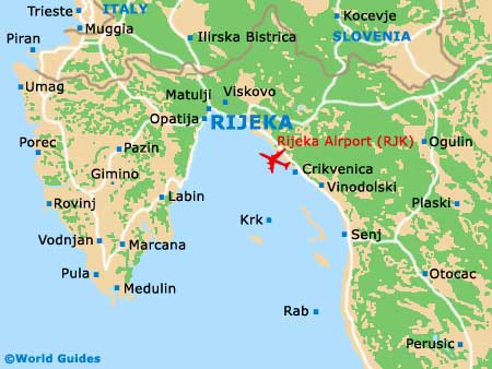
Maps and Orientation of the City
The centre of Rijeka's visitor activities and attractions is its Old Quarter, close to its commercial centre, which backs the immense port running along almost all of the city's coastline. Most of the hotels and lodging options are set back from the port by several blocks, amid the 19th-century mansions and ancient churches around the main square.
Along the bay to the north lies the Opatija Riviera, centred around the 19th-century summer haunts of the northern European royalty and nobility. Apart from the port, most of the industrial development of Rijeka is on the outskirts of the city and within the suburbs. The city's small seasonal airport is located on an island 30 km / 19 miles from downtown. Tourist maps of the city and of the Opatija Riviera can be found at hotel front desks and at the official tourist information office on the pedestrianised Korzo, next to the Trg Ivana Koblera.
- Bakar - 15 km / 9 miles (20 minutes, south-east)
- Buzet - 49 km / 31 miles (one hour, north-west)
- Cavle - 9 km / 6 miles (15 minutes, north-east)
- Crikvenica - 35 km / 22 miles (45 minutes, south-east)
- Dubrovnik - 595 km / 370 miles (seven hours and 30 minutes, south-east)
- Jadranovo - 28 km / 18 miles (30 minutes, south-east)
- Karlovac - 113 km / 71 miles (one hour and 30 minutes, east)
- Kostrena - 7 km / 4 miles (ten minutes, south-east)
- Kraljevica - 22 km / 14 miles (25 minutes, south-east)
- Ljubljana - 116 km / 73 miles (one hour and 35 minutes, north)
- Lovran - 20 km / 12 miles (25 minutes, south-west)
- Matulji - 11 km / 7 miles (15 minutes, west)
- Moscenicka Draga - 26 km / 16 miles (30 minutes, south-west)
- Novi Vinodolski - 45 km / 28 miles (55 minutes, south-east)
- Opatija - 14 km / 9 miles (20 minutes, west)
- Rabac - 63 km / 39 miles (one hour and 20 minutes, south-west)
- Split - 360 km / 224 miles (five hours, south-east)
- Trsat - 6 km / 4 miles (ten minutes, north-east)
- Volosko - 13 km / 8 miles (20 minutes, west)
- Zagreb - 161 km / 100 miles (two hours, north-east)
Map of Croatia
Map of Rijeka