Zadar Maps and Orientation
(Zadar, Northern Dalmatia, Croatia)
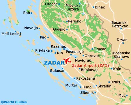
Zadar is a major city in the middle of Croatia's Adriatic coast (in Dalmatia), lying about 285 km / 177 miles south-west of the capital city, Zagreb. It has an ancient core and a newer centre - where the current city centre is based, and faces several near-shore islands. Zadar is split into many parts and requires good maps for getting about.
The Old Town is where most of the sights reside and this part of the city is today joined to the mainland courtesy of landfill. It has a warren of old alleys and nooks and crannies. Of note, you can find local maps at the Zadar Tourist Information Centre on the Mihe Klaica - next to the Narodni Trg, or on the Ilije Smiljanica bb.
Maps and Orientation of the City
The harbour is located to the north-east of the old core, while the Kolovare residential area is off to the east and the buzzing suburb of Borik to the north. The streets are, for the most part, well marked and all of these areas can be safely negotiated on foot with Zadar maps.
If you want to come prepared, it is best not to rely on the airport for maps, or until you get in the city and visit the tourist information office. If you require an all-encompassing guide while in Zadar, however, look to the Petar Zoranic bookstore, which is situated on the Knezova Subica Bribirskih.
- Benkovac - 36 km / 22 miles (40 minutes, east)
- Bibinje - 8 km / 5 miles (ten minutes, south)
- Biograd na Moru - 30 km / 19 miles (35 minutes, south)
- Dubrovnik - 373 km / 232 miles (five hours, south-east)
- Gospic - 99 km / 62 miles (one hour and 40 minutes, north)
- Gracac - 66 km / 41 miles (one hour and ten minutes, north-east)
- Krka National Park - 70 km / 43 miles (one hour and 15 minutes, south-west)
- Nin - 18 km / 11 miles (25 minutes, north)
- Pag - 53 km / 33 miles (one hour, north)
- Plitvice Lakes National Park - 40 km / 25 miles (50 minutes, north-west)
- Policnik - 16 km / 10 miles (20 minutes, north-east)
- Rijeka - 290 km / 180 miles (three hours, north)
- Sibenik - 91 km / 57 miles (one hour and 30 minutes, south-east)
- Skradin - 75 km / 47 miles (one hour and 20 minutes, south-east)
- Split - 150 km / 93 miles (one hour and 50 minutes, south-east)
- Starigrad - 45 km / 28 miles (55 minutes, north-east)
- Sukosan - 12 km / 7 miles (15 minutes, south)
- Zadar Airport - 12 km / 8 miles (15 minutes, east)
- Zagreb - 285 km / 177 miles (three hours, north-east)
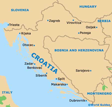
Map of Croatia
Map of Zadar