Bandung Maps and Orientation
(Bandung, West Java, Indonesia)
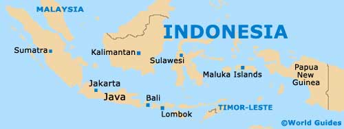
Located on the Indonesian island of Java, the city of Bandung serves as the capital of the entire West Java province and has a population fast approaching three million residents. This makes Bandung the fourth-biggest city in the country, and certainly one of the most important.
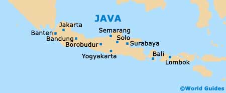
Bandung is situated approximately 120 km / 75 miles to the south-east of Jakarta and its metropolitan area is particularly densely populated. The city is rather spreading in nature and encompasses the northern foothills of a vast and very scenic plateau.
Maps and Orientation of the City
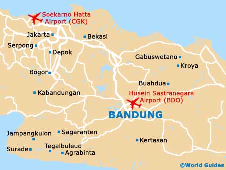
The main part of Bandung lies on the southerly side of the railway track, being centred around both the Jalan Asia Afrika and also the main square (the Alun Alun). The Jalan Asia Afrika is of particular significance to tourists visiting Bandung, since it is home to the post office and the tourist office, where free maps and booklets are available.
During the past colonial period, the railway line was a dividing line in Bandung, separating the poor southern residents from the more affluent northerly Dutch neighbourhood. Today, the northern side of Bandung is bounded by the Dago Hills and is filled with attractive residential areas, streets lined with old trees, and spacious parklands.
- Bekasi - 115 km / 71 miles (one hour and 40 minutes, north-west)
- Bogor - 125 km / 78 miles (two hours, west)
- Borobudur - 370 km / 230 miles (six hours and 30 minutes, south-east)
- Ciamis - 110 km / 68 miles (one hour and 45 minutes, south-east)
- Cilacap - 220 km / 137 miles (four hours, south-east)
- Indramayu - 135 km / 84 miles (two hours and 30 minutes, north)
- Jakarta - 120 km / 75 miles (one hour and 50 minutes, north-west)
- Lembang - 13 km / 8 miles (25 minutes, north)
- Pameungpeuk - 17 km / 11 miles (25 minutes, south)
- Semarang - 365 km / 227 miles (six hours and 30 minutes, east)
- Serang (Banten) - 225 km / 140 miles (two hours and 15 minutes, north-west)
- Tegal - 207 km / 129 miles (three hours and 30 minutes, east)
Map of Indonesia
Map of Java
Map of Bandung