Arlington Maps and Orientation
(Arlington, Virginia - VA, USA)
Arlington boasts strong connections to the US capital,
Washington D.C., which lies across the Potamac River and is connected by the Theodore Roosevelt Bridge (Teddy Roosevelt Bridge). This busy bridge carries both the US-50 and Interstate I-66, crossing the Potamac River from the easterly Rosslyn area of Arlington and passing by the Theodore Roosevelt Island and its memorial statue.
The George Washington Memorial Parkway is another important local thoroughfare lying on the eastern side of Arlington and edging much of the river, connecting all of the bridges. These include the 14th Street Bridge, the Rochambeau Memorial Bridge, the Arlington Memorial Bridge and Key Bridge. The parkway then heads northwards to the Scotts Run Nature Preserve and the Capital Bellway (Interstate I-495).
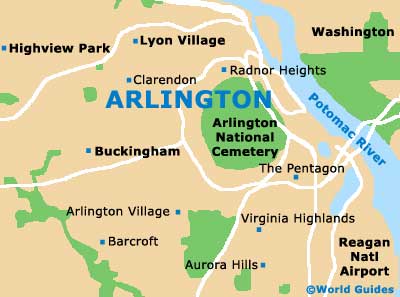
The riverside is where many of the principal attractions reside, such as the Potomac Overlook Park and the Fort CF Smith Park. The famous Arlington National Cemetery is also located close to the river, being home to the Tomb of the Unknowns (Tomb of the Unknown Soldier), the President John F. Kennedy Gravesite, the Robert F. Kennedy Gravesite, the Robert E. Lee National Memorial and Arlington House.
Maps and Orientation of the City
Many visitors choose to base themselves in Arlington and take day trips into neighboring Washington, following the simple route on maps.
Should you be looking for maps, either ask at your hotel's front desk or pay a visit to Pentagon Row, where the local Visitors Center resides on South Joyce Street, next to the Pentagon City Mall and close to the Drug Enforcement Administration (DEA) Museum on Army Navy Drive.
- Alexandria - 9 miles / 14 km (15 minutes, southeast)
- Annandale - 7 miles / 11 km (15 minutes, southwest)
- Baltimore - 45 miles / 72 km (one hour and five minutes, northeast)
- Bethesda - 12 miles / 19 km (22 minutes, north)
- Brightwood - 10 miles / 16 km (20 minutes, northeast)
- Brookmont - 8 miles / 13 km (15 minutes, north)
- Burke - 14 miles / 23 km (25 minutes, southwest)
- Fairfax - 13 miles / 21 km (25 minutes, west)
- Hybla Valley - 12 miles / 19 km (22 minutes, south)
- Mantua - 10 miles / 16 km (20 minutes, west)
- Newington - 15 miles / 24 km (25 minutes, south)
- Potomac - 16 miles / 26 km (30 minutes, northwest)
- Reston - 16 miles / 26 km (30 minutes, west)
- Seminary Hill - 7 miles / 11 km (15 minutes, south)
- Springfield - 11 miles / 18 km (20 minutes, southwest)
- Washington D.C. - 5 miles / 8 km (12 minutes, east)
- West Falls Church - 6 miles / 10 km (12 minutes, west)
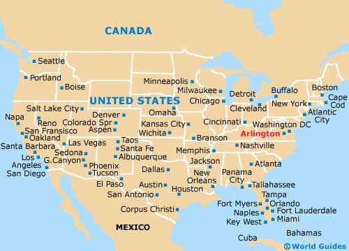
Map of the United States
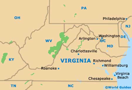
Map of Virginia
Map of Arlington