Austin Maps and Orientation
(Austin, Texas - TX, USA)
Austin is an especially important Texan city, since it is the capital of
Texas and also serves as the county seat (administrative center) of Travis County. The city of Austin also ranks as the 'Live Music Capital of the World' and is known for its undeniable quirky character.
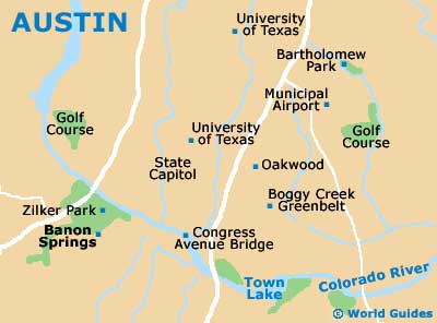
Finding your way around Austin is not usually difficult, with a number of notable streets intersecting the city center. Both Guadalupe Street and the Lamar Boulevard head in a northeast to southwest direction, running parallel with each other and passing by the University of Texas before reaching downtown.
Located on the northern side of the university is the neighborhood known as Hyde Park, while the area around East 6th Street boasts a high concentration of lively nightspots. Of note, the Warehouse District is close by and just a relatively short stroll away.
Maps and Orientation of the City
The Texas State Highway Loop US-1 bounds the western axis of Austin, with the Interregional Highway US-290 passing through the eastern edge of the city center itself. Further afield, the small city of Round Rock is just a half hours' drive to the north, with the northwesterly Balcones Canyonlands National Wildlife Refuge being in the region of an hour away by car and next to Burnet County's town of Marble Falls - part of the spreading Highland Lakes.
If you are in the need of maps, then the Austin Convention and Visitors Bureau on East 6th Street should be your first port of call.
- Balcones Canyonlands National Wildlife Refuge - 42 miles / 68 km (one hour and five minutes, northwest)
- Belton - 60 miles / 97 km (one hour and 20 minutes, north)
- College Station - 107 miles / 172 km (two hours and 30 minutes, east)
- Corpus Christi - 210 miles / 338 km (five hours, southeast)
- Georgetown - 27 miles / 43 km (45 minutes, north)
- Gonzales - 62 miles / 100 km (one hour and 20 minutes, southeast)
- Houston - 160 miles / 257 km (four hours, east)
- Jollyville - 15 miles / 24 km (25 minutes, north)
- Killeen - 68 miles / 109 km (one hour and 40 minutes, north)
- Lakeway - 22 miles / 35 km (40 minutes, northwest)
- Marble Falls - 48 miles / 77 km (one hour and ten minutes, northwest)
- McKinney Falls State Park - 9 miles / 14 km (15 minutes, south)
- New Braunfels - 44 miles / 71 km (one hour and five minutes, southwest)
- Round Rock - 19 miles / 31 km (35 minutes, north)
- San Antonio - 80 miles / 129 km (one hour and 55 minutes, southwest)
- San Marcos - 32 miles / 51 km (50 minutes, southwest)
- Temple - 68 miles / 109 km (one hour and 40 minutes, north)
- Waco - 104 miles / 167 km (two hours and 25 minutes, north)
Map of the United States
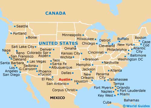
Map of Texas

Map of Austin