Wichita Maps and Orientation
(Wichita, Kansas - KS, USA)
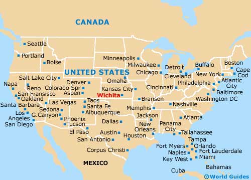
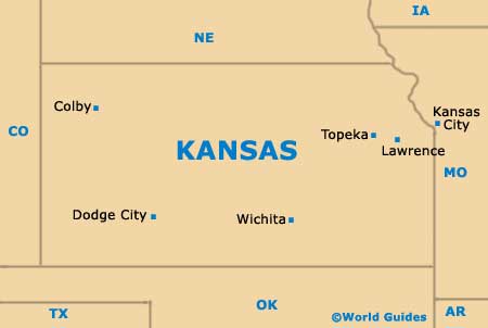
Located on the southern side of Kansas and roughly 50 miles / 80 km from the border with Oklahoma, the city of Wichita serves as the state's biggest city, although it is the considerably smaller city of
Topeka the boasts the title of state capital.
Wichita is, however, the seat for Sedgwick County, as well as the main city within the sprawling Wichita Metropolitan Area. The metro area also incorporates the counties of Butler, Harvey and Sumner, as well as the small cities of Andover, Derby, El Dorado, Haysville and Newton.
Prominent roads connecting the city with the rest of Kansas include the I-135 Interstate, which heads northwards to Newton and beyond. The I-35 (Kansas Turnpike) runs in a southerly direction, heading all the way to
Oklahoma City (roughly 160 miles / 257 km away), as well as to El Dorado and Emporia, to the northeast.
Maps and Orientation of the City
The historic Old Town of Wichita is known for its characterful red-brick buildings and plentiful shops, bars and restaurants. Sited on the eastern side of Wichita, the Old Town is understandably a popular hangout for tourists, as is the 'Museums on the River' district and its plentiful cultural attractions, close to both the Little Arkansas River and the Big Arkansas River. The botanical gardens here are especially appealing.
Maps of the city can be obtained at the Wichita Visitor Center, which is located on South Main Street, close to the Fairfield Inn Hotel and just a short distance from the Lawrence Dumont Stadium.
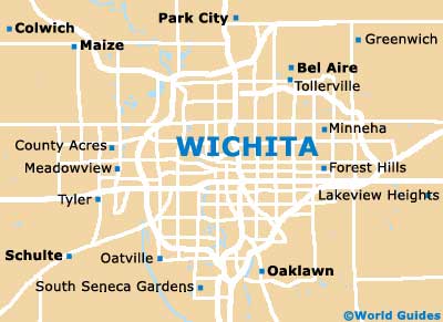
- Andover - 14 miles / 23 km (25 minutes, east)
- Bel Aire - 9 miles / 14 km (15 minutes, northeast)
- Belle Plaine - 26 miles / 42 km (40 minutes, south)
- Colwich - 18 miles / 29 km (35 minutes, northwest)
- Goddard - 14 miles / 23 km (25 minutes, west)
- Haysville - 12 miles / 19 km (20 minutes, south)
- Hutchinson - 51 miles / 82 km (one hour and 20 minutes, northwest)
- Maize - 15 miles / 24 km (30 minutes, northwest)
- Mulvane - 21 miles / 34 km (35 minutes, southeast)
- Newton - 28 miles / 45 km (45 minutes, north)
- Oaklawn - 7 miles / 11 km (15 minutes, southeast)
- Park City - 9 miles / 14 km (15 minutes, north)
- Schulte - 11 miles / 18 km (20 minutes, southwest)
- Valley Center - 14 miles / 23 km (25 minutes, north)
Map of the United States
Map of Kansas
Map of Wichita