Carmel Maps and Orientation
(Carmel - Carmel-by-the-Sea, Monterey County, California - CA, USA)
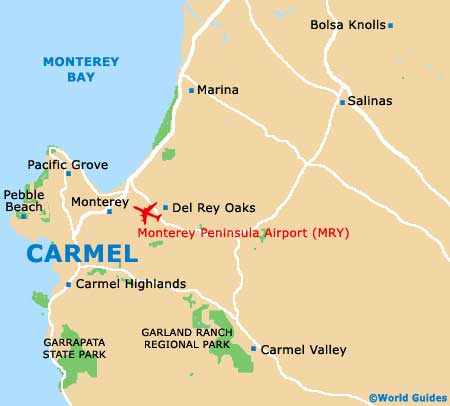
Situated in central California and close to a number of very famous cities, Carmel-by-the-Sea (Carmel) is located next to the Californian coastline and close to Pebble Beach. On the northerly outskirts of Carmel, the Cabrillo Highway (US-1) heads northwards to Marina and towards the popular cities of
San Francisco,
Oakland and
San Jose.
Close to home, Carmel is just a stone's throw from
Monterey and Pacific Grove, and north of
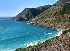
Big Sur. Head further south and along Interstate 5 and you will reach
Los Angeles,
Long Beach and Huntington Beach, and eventually, also
San Diego and Tijuana.
Maps and Orientation of the Town
To the east of Carmel-by-the-Sea, Carmel Valley is easy to reach and is located alongside the spreading Garland Ranch Regional Park and Robles Del Rio. This beautiful valley is home to its very own town, which has become known for its laid back approach to life, numerous vineyards, and quality golf courses, such as the very affordable Rancho Canada Golf Club off the Carmel Valley Road, directly east of the Highway 1.
Unless you are planning to explore the California lying outside of Carmel, maps are not really necessary. However, if you choose to drive along the very scenic and equally famous 17 Mile Drive, then maps are strongly recommended, so that you will be able to find the best places to spot off and enjoy the stunning views. Within the center of Carmel itself, the Ocean Avenue serves as the main thoroughfare and is flanked with a good selection of stores, galleries and eateries, leading towards a very pretty beachfront.
- Anaheim - 373 miles / 600 km (six hours, southeast)
- Andrew Molera State Park - 20 miles / 32 km (30 minutes, south)
- Big Sur - 26 miles / 42 km (35 minutes, south)
- Carmel Valley - 13 miles / 21 km (20 minutes, southeast)
- Del Monte Forest - 4 miles / 6 km (ten minutes, northwest)
- Julia Pfeiffer Burns State Park - 30 miles / 48 km (45 minutes, south)
- Los Angeles - 347 miles / 558 km (five hours and 30 minutes, southeast)
- Monterey - 4 miles / 6 km (ten minutes, north)
- Oakland - 115 miles / 185 km (two hours and ten minutes, north)
- Pacific Grove - 6 miles / 10 km (14 minutes, north)
- Pebble Beach - 3 miles / 5 km (six minutes, west)
- Redwood - 66 miles / 106 km (one hour and 20 minutes, north)
- Richmond - 126 miles / 203 km (two hours and 30 minutes, north)
- Sacramento - 190 miles / 306 km (three hours and 45 minutes, northeast)
- Salinas - 22 miles / 35 km (30 minutes, east)
- San Diego - 467 miles / 752 km (seven hours and 25 minutes, southeast)
- San Francisco - 122 miles / 196 km (two hours and 30 minutes, north)
- San Jose - 75 miles / 121 km (one hour and 25 minutes, north)
- Sand City - 8 miles / 13 km (15 minutes, northeast)
- Santa Barbara - 252 miles / 406 km (four hours and 15 minutes, southeast)
- Santa Cruz - 46 miles / 74 km (55 minutes, north)
- Seaside - 7 miles / 11 km (12 minutes, northeast)
- Toro Regional Park - 16 miles / 26 km (27 minutes, east)
Map of the United States

Map of California

Map of Carmel