Inverness Maps and Orientation
(Inverness, Scotland, UK)
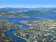
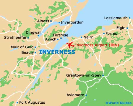
Inverness is the capital of the Highlands, situated just north of Great Glen and Loch Ness. The city is surrounded by glens and rolling heath-covered countryside. Moray Firth and Beauly Firth lie immediately north as they empty into the North Sea.
Inverness is the commercial and cultural hub of the northern part of
Scotland and has towns like Nairn, Dingwall and
Fort Augustus as its neighbours. The city itself spreads out on both sides of the Ness River. Several bridges connect the eastern and western parts of Inverness, both of which have a mix of commercial and residential activity.
The historic and commercial core of the city is the High Street, a pedestrian area lined with countless shops, restaurants, galleries and bars. Ness Bridge connects Young Street with Bridge Street, the latter of which runs east into the High Street.
Maps and Orientation of the City
Most of the tourist attractions and historic sites are located on the eastern side of the Ness River, around the High Street district. From Friars Bridge to the Eastgate Precinct, you will find the most enjoyable and interesting part of Inverness. Highlights such as the Victorian Market and the Old High Church are here. Immediately to the south of the High Street is the
Inverness Castle area, a pleasant residential neighborhood worth exploring.
There are plenty of good maps available of the city centre and you can generally find them at most local inns and hotels. The Highlands of Scotland Tourist Board at Castle Wynd is the city's main tourism information centre. It is open every day throughout the summer, with limited winter hours, and offers a wealth of brochures, maps and useful information about Inverness and the surrounding countryside, where many of the top attractions in the Highlands are located. Alternatively, maps can be purchased from the Waterstones bookstore on the High Street.
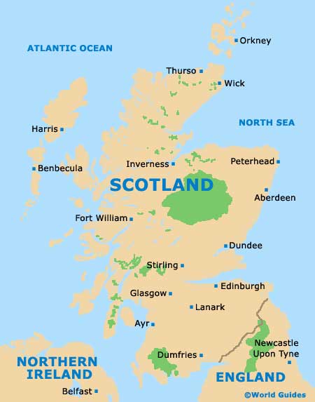
- Aberdeen - 166 km / 104 miles (three hours and ten minutes, east)
- Allangrange Mains - 11 km / 7 miles (15 minutes, north-west)
- Bunchrew House - 6 km / 4 miles (ten minutes, west)
- Craigton - 68 km / 42 miles (50 minutes, north)
- Dingwall - 25 km / 16 miles (30 minutes, north-west)
- Dundee - 220 km / 138 miles (two hours and 45 minutes, south-east)
- Dunmaglass - 32 km / 20 miles (35 minutes, south)
- Edinburgh - 251 km / 156 miles (three hours, south)
- Essich - 8 km / 5 miles (ten minutes, south)
- Glasgow - 274 km / 170 miles (three hours and 30 minutes, south)
- Leys Castle - 8 km / 5 miles (ten minutes, south)
- Loch Duntelchaig - 19 km / 12 miles (25 minutes, south)
- Loch Ness - 21 km / 13 miles (25 minutes, south)
- Munlochy - 18 km / 11 miles (25 minutes, north)
- Nairn - 32 km / 20 miles (35 minutes, north-east)
- Redcastle - 16 km / 10 miles (20 minutes, north-west)
- Stirling - 233 km / 145 miles (two hours and 45 minutes, south)
- Urqhart Castle - 21 km / 13 miles (20 minutes, south)
Map of the United Kingdom

Map of Scotland
Map of Inverness