Dundee Maps and Orientation
(Dundee, Scotland, UK)
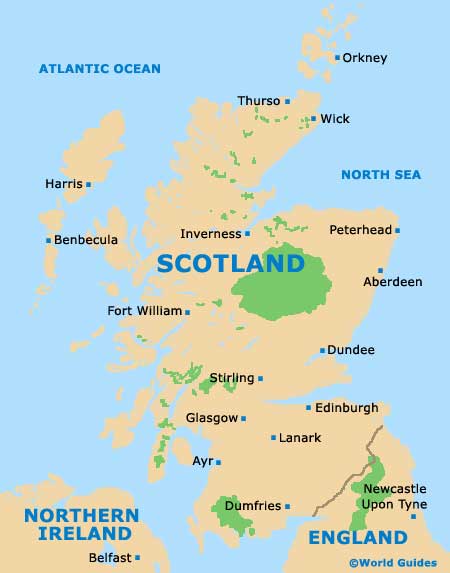
The city of Dundee has grown up next to the Firth of Tay estuary, along the rugged north-eastern coast of
Scotland. Set on a narrow plain backed by rolling hills and south of the Cairngorm Mountains, the city gives easy access to
Edinburgh,
Aberdeen and the scenic centre of the country. Dundee is surrounded by numerous smaller towns and villages boasting agricultural and fishing traditions, each with their own flavour.
The seacoast here has tiny bays, spectacular cliffs and rock formations, and the area around Dundee has no fewer than 50 golf courses set amid stunning natural scenery. To the north of Dundee lies Aberdeen, and Edinburgh is a comfortable drive south. Maps of the region and Scotland itself can be obtained at the city's Tourist Centre at
Discovery Quay, or purchased from the Waterstones bookshop on Commercial Street.
Maps and Orientation of the City
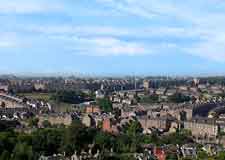
The heart of Dundee is its riverside area, with Discovery Quay and the port just a short walk from downtown, the pedestrianised main square and the High Street shopping, dining, nightlife and accommodation hub. Dundee is a comparatively compact city, straightforward to get around whether by car, bus or on foot. There is a small but growing cultural district around the University of Dundee, with several parks and green spaces in this part of the city.
The city and its suburbs are densely populated and inner city housing is characterised by 19th-century four-storey tenements, many of which are being converted into apartment blocks to replace the ugly 1960s concrete towers now slowly being demolished. To the east of the main city lies Broughty Ferry, the exclusive suburb once called home by the 19th-century jute mill owners.
- Aberdeen - 104 km / 65 miles (one hour and 40 minutes, north-east)
- Aberlemno - 35 km / 22 miles (45 minutes, north-east)
- Angus Glens - 37 km / 23 miles (45 minutes, north)
- Arbroath - 29 km / 18 miles (34 minutes, east)
- Blairgowrie - 31 km / 19 miles (40 minutes, north-west)
- Brechin - 43 km / 27 miles (50 minutes, north-east)
- Cupar - 21 km / 13 miles (30 minutes, south)
- Edinburgh - 90 km / 56 miles (one hour and 25 minutes, south-west)
- Edzell - 51 km / 32 miles (55 minutes, north-east)
- Forfar - 39 km / 24 miles (45 minutes, north)
- Glamis - 20 km / 12 miles (25 minutes, north)
- Glasgow - 130 km / 81 miles (one hour and 45 minutes, south-west)
- Glenrothes - 40 km / 25 miles (50 minutes, south)
- Helensburgh - 142 km / 89 miles (two hours and four minutes, west)
- Inverness - 220 km / 138 miles (two hours and 45 minutes, north-west)
- John O' Groats - 406 km / 254 miles (five hours and 20 minutes, north)
- Kirkcaldy - 48 km / 30 miles (55 minutes, south)
- Kirriemuir - 31 km / 19 miles (40 minutes, north)
- Montrose - 46 km / 29 miles (55 minutes, north-east)
- Perth - 35 km / 22 miles (35 minutes, west)
- Scone - 32 km / 20 miles (35 minutes, west)
- St. Andrews - 21 km / 13 miles (25 minutes, south-east)
- Stirling - 90 km / 56 miles (one hour and 20 minutes, south-west)
Map of the United Kingdom

Map of Scotland
Map of Dundee

