Bonn Maps and Orientation
(Bonn, North Rhine-Westphalia, Germany)
Known for its proximity to
Cologne, the city of Bonn stands next to the Rhine River, in the German state of North Rhine-Westphalia. Located on the western side of Germany, Bonn was actually the capital of West Germany until the reunification of Berlin in 1990 and today remains an important centre for politics.
Despite Bonn losing its capital status, the city has retained much of its prosperity and surprised many locals by gaining a new, strong identity. Many major corporations and international organisations have flocked to Bonn during the latter part of the 20th century, including a prestigious group of UN offices.
Maps and Orientation of the City
Historically, Bonn has expanded and swallowed up a number of surrounding towns and villages, which have become suburbs of this spreading city. These include the towns of both Beuel and Bad Godesberg in the late 1960s, when Bonn began to grow at such a pace that it was soon double its previous size.
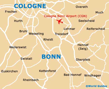
Apart from Cologne lying to the north-east and reached along the B9, Bonn is also close to many other prominent locations, such as the Siebengebirge Nature Reserve to the south. Also nearby is the busy Koln-Bonn Airport, which is just a short drive to the north, and the following cities, towns and villages.
- Aachen - 90 km / 56 miles (one hour and 15 minutes, west)
- Alfter - 8 km / 5 miles (12 minutes, west)
- Bad Honnef - 19 km / 12 miles (20 minutes, south-east)
- Bornheim - 10 km / 6 miles (12 minutes, north-west)
- Cologne - 25 km / 16 miles (25 minutes, north-east)
- Erftstadt - 40 km / 25 miles (40 minutes, west)
- Euskirchen - 48 km / 30 miles (45 minutes, south-west)
- Koblenz - 80 km / 50 miles (one hour and 10 minutes, south-east)
- Königswinter - 14 km / 9 miles (15 minutes, south-east)
- Lohmar - 18 km / 11 miles (20 minutes, north-east)
- Mechernich - 62 km / 39 miles (50 minutes, south-west)
- Rheinbach - 27 km / 17 miles (25 minutes, south-west)
- Siegburg - 16 km / 10 miles (17 minutes, east)
- Troisdorf - 16 km / 10 miles (17 minutes, north-east)
- Wesseling - 14 km / 9 miles (15 minutes, north-west)
Map of Germany

Map of Bonn