Rothenburg ob der Tauber Maps and Orientation
(Rothenburg ob der Tauber, Bavaria, Germany)
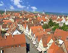
Rothenburg ob der Tauber's medieval Old Town is small enough to see entirely by walking around its quaint streets and cars are either discouraged or forbidden in the area.
Maps of the sights within the town walls of Rothenburg ob der Tauber can be sourced at your hotel's front desk, or at the town's tourist office located in the Marktplatz. If you prefer to plan your days ahead of your arrival, online maps of the town are easily downloaded.
Maps and Orientation of the Town
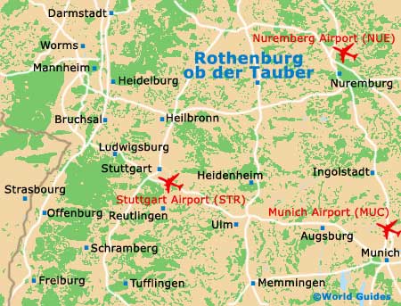
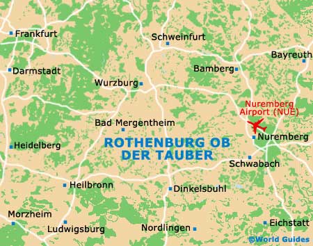
Rothenburg ob der Tauber lies in south-central Bavaria, conveniently situated halfway between the major cities of
Munich and
Frankfurt, on Bavaria's quaintly-named Romantic Road.
For the committed sightseer, Bavaria boasts everything for a memorable touring holiday, from castles, medieval heritage buildings, breathtaking scenery and vineyards, to charming old towns and villages. German roads are known for their drivability, and your chosen car rental company should be able to provide you with maps of Bavaria.
- Ansbach - 34 km / 21 miles (35 minutes, south-east)
- Augsburg - 184 km / 114 miles (two hours and 30 minutes, south
- Bad Mergentheim - 42 km / 26 miles (45 minutes, north-west)
- Bamberg - 151 km / 94 miles (two hours, north-east)
- Bayreuth - 184 km / 114 miles (two hours and 30 minutes, north-east)
- Diebach - 10 km / 7 miles (13 minutes, south)
- Dinkelsbuhl - 49 km / 30 miles (50 minutes, south)
- Erlangen - 131 km / 81 miles (one hour and 45 minutes, north-east)
- Furth - 72 km / 45 miles (one hour and ten minutes, east)
- Geslau - 11 km / 8 miles (14 minutes, east)
- Munich (München) - 244 km / 152 miles (three hours, south-east)
- Niederstetten - 27 km / 17 miles (30 minutes, west)
- Nordlingen - 91 km / 57 miles (one hour and 25 minutes, south)
- Nuremberg (Nurnberg) - 69 km / 43 miles (one hour, east)
- Regensburg - 198 km / 123 miles (two hours and 45 minutes, east)
- Satteldorf - 40 km / 25 miles (45 minutes, south)
- Stuttgart - 148 km / 92 miles (one hour and 55 minutes, south-west)
- Wettringen - 17 km / 11 miles (20 minutes, south)
- Wurzburg - 73 km / 45 miles (one hour, north)
Map of Germany

Map of Rothenburg ob der Tauber