Sumatra Maps and Orientation
(Sumatra, Indonesia)
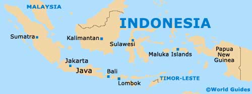
The Indonesian island of Sumatra is located on the western side of the country, where it is one of the most noteworthy of the Sunda Islands. Sumatra is actually the biggest of all the islands that are situated completely within Indonesia, since both Borneo and New Guinea are actually only part Indonesian.
Being the sixth-biggest island on the planet, Sumatra really is quite vast and you should definitely take your time deciding where best to base yourself. Maps are always essential for those planning to self-navigate, rather that join a tour.
Maps and Orientation of the Island
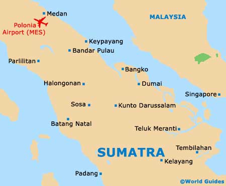
In North Sumatra, Medan serves as the capital and is a huge city, with a population of more than two million residents. Also in North Sumatra are the popular destinations of Berastagi, Gunung Sibayak, Gunung Sinabung, Lake Toba, Parapat, Pematangsiantar (Pematang Siantar), and Bukit Lawang - the main gateway into the Gunung Leuser National Park.
Other important provinces include Aceh, Bangka-Belitung, Bengkulu, Jambi, Lampung, Riau, West Sumatra (Barat), and South Sumatra (Selatan), the latter of which is home to both the cities of Palembang and Prabumulih.
- Bali - south-east
- Belitung Island (Pulau Belitung) - east
- Bandung (West Java) - south-east
- Banten (West Java) - south-east
- Enggano Island (Pulau Enggano) - south-west
- Jakarta (West Java) - south-east
- Kalimantan - east
- Kuala Lumpur (Malaysia) - north
- Lombok Island - south-east
- Maluku Islands - east
- Mentawai Islands - west
- Nias Island (Pulau Nias) - west
- Pangkai Pinang (Bangka) - east
- Riau Islands - east
- Siberut Island (Pulau Siberut) - west
- Simeulue Islands (Pulau Simeulue) - west
- Singapore - north
- Sulawesi Island - east
Map of Indonesia
Map of Sumatra