Lancaster Maps and Orientation
(Lancaster, Pennsylvania - PA, USA)
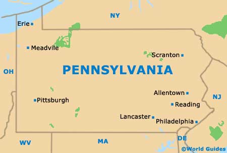
Located within the southeastern quarter of Pennsylvania, Lancaster is roughly 70 miles / 113 km to the west of
Philadelphia and just under 40 miles / 64 km to the southeast of
Harrisburg.
The city serves as the seat of Lancaster County and belongs to the sizeable Lancaster Metropolitan Area, which boasts a population of approximately 525,000 people.
Various major thoroughfares connect the city with the rest of Pennsylvania. Highway US-30 heads in an east to west direction, the US-222 links the northeast, and the PA-283 runs to Elizabethtown and the Harrisburg International Airport in the northwest.
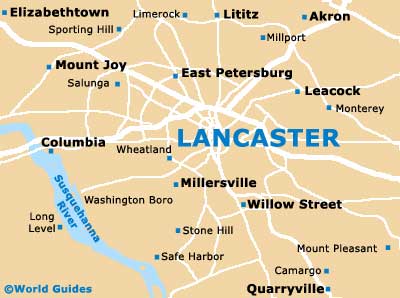
Maps and Orientation of the City
Downtown Lancaster is one of straight, criss-crossing streets, with prominent thoroughfares including the Lincoln Highway, Chestnut Street, Walnut Street, Prince Street and Queen Street.
Maps make getting around all the easier, being available from the Pennsylvania Dutch Convention and Visitors Bureau, close to the Hampton Inn and Courtyard hotels.
- Baumgardner - 6 miles / 10 km (12 minutes, south)
- Bellemont - 15 miles / 24 km (30 minutes, southeast)
- Elizabethtown - 20 miles / 32 km (35 minutes, northwest)
- Ephrata - 16 miles / 26 km (30 minutes, northeast)
- Gordonville - 12 miles / 19 km (25 minutes, east)
- Harristown - 14 miles / 23 km (25 minutes, southeast)
- Holtwood - 19 miles / 31 km (35 minutes, south)
- Kinderhook - 11 miles / 18 km (20 minutes, west)
- Kreutz Creek - 19 miles / 31 km (35 minutes, west)
- Lititz - 9 miles / 14 km (15 minutes, north)
- Millersville - 4 miles / 6 km (ten minutes, southwest)
- Mount Joy - 13 miles / 21 km (25 minutes, west)
- Mountville - 7 miles / 11 km (15 minutes, west)
- New Holland - 14 miles / 23 km (25 minutes, east)
- Poplar Grove - 15 miles / 24 km (30 minutes, north)
- Willow Street - 4 miles / 6 km (ten minutes, south)
- Wrightsville - 12 miles / 19 km (25 minutes, west)
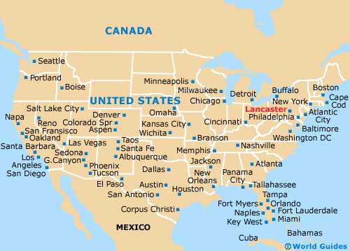
Map of the United States
Map of Pennsylvania
Map of Lancaster