Bismarck Maps and Orientation
(Bismarck, North Dakota - ND, USA)
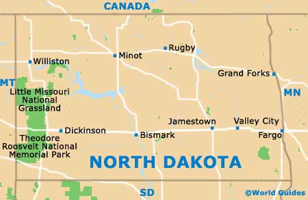
North Dakota resides on the very northern side of North America, in the center of the border with neighboring Canada. The city of Bismarck is actually in the region of 160 miles / 250 km from the Canadian border, with both Boissevain and Killarney being amongst the closest towns in Canada.
Bismarck serves as the state capital, as well as being the county seat for Burleigh County. It has a population of around 70,000 people, while Fargo is the state's biggest city and comes with roughly 110,000 residents.
The city is separated from the neighboring town of Mandan by the Missouri River, which marks the western border and runs in a north to south direction. Interstate I-94 is to be found on the northern outskirts of the city, where it runs east to west, ultimately connecting North Dakota with the states of
Minnesota (east) and
Montana (west).
Maps and Orientation of the City
In the city itself, visitors will find that maps show downtown Bismarck as an organized series of similarly sized square blocks. Named avenues run east to west, and numbered streets head north to south. The North Dakota State Capitol Grounds reside on the northern side of the city center, along with Lions Park and part of the Hay Creek Trail.
Head to the southeast and you will come upon Bismarck Airport, and further south, the University of Mary and the Sibley Nature Park.
- Apple Valley - east
- Dickinson - west
- Fort Abraham Lincoln State Park - southwest
- General Sibley Park - south
- Harmon - northwest
- Huff Hills Ski Area - south
- Jamestown - east
- Lincoln - southeast
- Mandan - west
- Medora - west
- Minot - north
- New Salem - west
- Valley City - east
- Washburn - north
Map of USA
Map of North Dakota
Map of Bismarck
