Omaha Maps and Orientation
(Omaha, Nebraska - NE, USA)
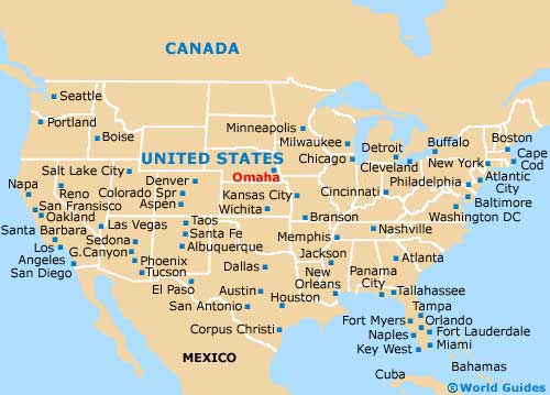
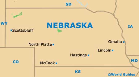
The city of Omaha resides on the far eastern side of Nebraska, right next to the neighboring state of
Iowa and just over an hour to the northeast of
Lincoln city. Omaha serves as the seat of Douglas County and is Nebraska's biggest city, while considerably smaller Lincoln is actually the state capital.
The history and layout of Omaha has been greatly influenced by the Missouri River, which winds its way through the city center, roughly north to south. The Interstate I-29 follows the line of the river, before joining the east to west Interstate I-80.
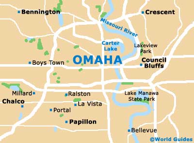
Omaha belongs to the Omaha-Council Bluffs Metropolitan Area, where lakes Carter, Glenn Cunningham and Manawa all reside. This spreading metropolitan area comprises no less than eight counties, three of which are located in Iowa. Apart from Omaha itself, other notable towns and cities belonging to this metro area include those of Bellevue, Blair, Council Bluffs, Glenwood, La Vista, Papillion, Plattsmouth and Ralston.
Maps and Orientation of the City
Finding your way around Omaha is made all the easier once you look on a map and understand the layout of the city. Most maps will show how the city is roughly divided into six principal zones, namely Downtown, Midtown, North, East, South and West.
Located in downtown Omaha and next to the riverside, the Old Market area is an especially appealing part of the city, suiting tourists looking for a stroll. Here you will find various old warehouses that have been converted into trendy clubs, shops and eateries, with waterfront walking trails and green parks being conveniently close by.
- Bellevue - 10 miles / 16 km (20 minutes, southeast)
- Bennington - 16 miles / 26 km (30 minutes, northwest)
- Blair - 26 miles / 42 km (40 minutes, north)
- Boys Town - 8 miles / 13 km (15 minutes, west)
- Chalco - 12 miles / 19 km (25 minutes, southwest)
- Council Bluffs - 8 miles / 13 km (15 minutes, east)
- Crescent - 15 miles / 24 km (30 minutes, northeast)
- Elkhorn - 14 miles / 23 km (25 minutes, west)
- Fort Calhoun - 22 miles / 35 km (35 minutes, north)
- Fremont - 34 miles / 55 km (50 minutes, northwest)
- Glenwood - 29 miles / 47 km (45 minutes, southeast)
- La Vista - 7 miles / 11 km (15 minutes, south)
- Millard - 12 miles / 19 km (25 minutes, southwest)
- Papillion - 9 miles / 14 km (20 minutes, south)
- Plattsmouth - 22 miles / 35 km (35 minutes, south)
- Ralston - 5 miles / 8 km (12 minutes, south)
Map of the United States
Map of Nebraska
Map of Omaha