Saint Paul Maps and Orientation
(Saint Paul, Minnesota - MN, USA)
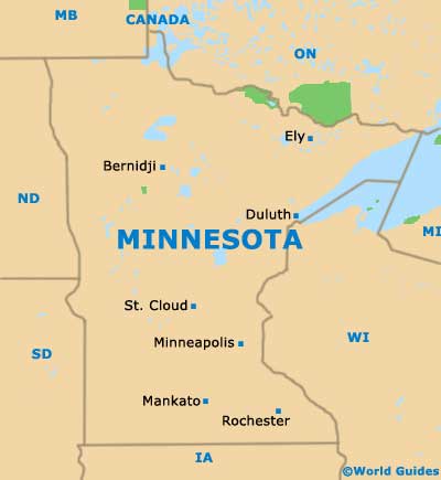
The state of Minnesota resides on the northern side of North America, in between the states of
North Dakota and
Wisconsin. St. Paul is the state capital, although it is not actually the biggest city in Minnesota. That accolade goes to its 'Twin City', adjacent
Minneapolis (to the west).
The city is bounded on its western axis by the Mississippi River, with the city being based roughly at the point where it meets with the Minnesota River. Together with Minneapolis, St. Paul is part of a huge metropolitan area, which has a combined population of close to 3.5 million.
From St. Paul, Minneapolis is easy to reach, being connected by Interstate I-94 / Highway US-52. Interstate I-35E heads northwards to Little Canada, while Highway US-52 (Lafayette Freeway) runs southwards.
Maps and Orientation of the City
Various neighborhoods make up the state capital of St. Paul, where many historically significant buildings and structures await sightseers. These include the neighborhoods of North End, West End, Greater East Side, West Side, Dayton's Bluff, Union Park and Summit Hill, all of which show on detailed city maps.
Downtown St. Paul is full of interest and is where you will find the Xcel Energy Center, the Galtier Plaza, Mears Park and Rice Park - one of the oldest parks in the whole of the United States. Many of the office blocks are interconnected by a network of 'skyways', reducing the number of pedestrians on the streets on the downtown district.
- Baldwin,Wisconsin (WI) - east
- Bloomington - southwest
- Brooklyn Park - northwest
- Burnsville - southwest
- Cambridge - north
- Eagan - southwest
- Faribault - south
- Hudson, Wisconsin (WI) - east
- Lakeville - southwest
- Little Canada - north
- Maplewood - east
- Minneapolis - west
- North Branch - north
- Owatonna - south
- Woodbury - east
Map of USA
Map of Minnesota

Map of Saint Paul
