Acapulco Maps and Orientation
(Acapulco, Guerrero, Mexico)
Officially known in Mexico as Acapulco de Juárez, this city lies within the Mexican state of Guerrero, alongside the beautiful Pacific coastline. A prominent sea port and tourist resort combined, the city is located in southern Mexico and overlooks a particularly scenic bay, the Bahia de Acapulco (also known as the Bahia de Santa Lucia).
At the western end of the bay you will find the Peninsula de las Playas, next to the Old Acapulco district, better known as 'Acapulco Nautico'. Many luxury resorts and beaches are sited in this area, including the Playa Hornos. To the north-west, the Pie de la Cuesta region tends to be more low key when it comes to the city's tourism industry and is a good place to visit if you wish to escape the crowds.
Maps and Orientation of the City
Acapulco is easy to reach by road and is close to Highway 95 (north) and Highway 200 (east and west). Around the city environs, visitors will soon discover that street signs are fairly scarce and many of the buildings are numbered somewhat erratically. However, most locals will be happy to direct you to your destination, if you are able to overcome the language barrier. Alternatively, consider investing in a good map of Acapulco, available from bookstores along La Costera.
Much of central Acapulco is typically Colonial Spanish in style and full of character, with the city's magnificent cathedral gracing the very heart of the old central commercial district.
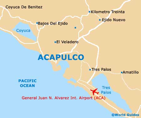
- Amatillo - east
- Bajos Del Ejido - north-west
- Coyuca De Benitez - north-west
- El Limon - east
- El Marques - south
- El Veladero - north
- Kilometro Treinta - north
- Las Vigas - east
- San Jeronimo De Juarez - north-west
- Tepetixtla - north-west
- Tierra Colorada - north-east
- Tixtlancingo - north
- Xaltianguis - north-east
Map of Mexico

Map of Acapulco