Baracoa Maps and Orientation
(Baracoa, Guantánamo, Cuba)
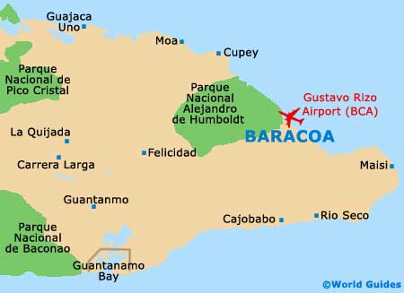
Baracoa lies on an enclosed bay in a magnificent natural harbour, within Guantanamo province and at the south-eastern tip of
Cuba, where it is encircled by mountains, including the Sierra del Puriel. The only access to this isolated city and its surroundings is by a recently-built mountain road culminating in a nine-span, 30-km / 19-mile long viaduct, a triumph of modern engineering.
The narrow plain on which Baracoa is set is given over to agriculture, mainly fruit and coconut palms, while the slopes of the mountains contain cacao and coffee plantations. Remote from the rest of Cuba, access to the city is limited. For travelling around the region, a good map is essential.
Maps and Orientation of the City
Baracoa, Cuba's oldest city, comprises an ancient colonial area, once a village and even now keeping its village layout. The small streets radiating from its centre contain single-storey houses painted in bright blues, greens and yellows.
The city retains its traditional neighbourhoods and most of the limited tourism activity takes place in the old town and down along the harbour and its promenade. Several rivers run through or near the city, entering the bay across the beaches. Local tourism maps should be available at the visitor centre and hotel front desks.
- Guantanamo - 150 km / 93 miles (two hours and 30 minutes, south-west)
- Havana - 993 km / 617 miles (15 hours and 30 minutes, north-west)
- Holguin - 250 km / 156 miles (four hours, north-west)
- Matanzas - 933 km / 579 miles (14 hours and 30 minutes, north-west)
- Mayari - 164 km / 102 miles (two hours and 30 minutes, north-west)
- Moa - 70 km / 43 miles (one hour and ten minutes, north-west)
- Pylon - 409 km / 254 miles (six hours and 30 minutes, west)
- Santiago de Cuba - 234 km / 145 miles (three hours and 30 minutes, west)
- Trinidad - 713 km /443 miles (11 hours, north-west)
- Varadero - 904 km / 561 miles (14 hours, north-west)
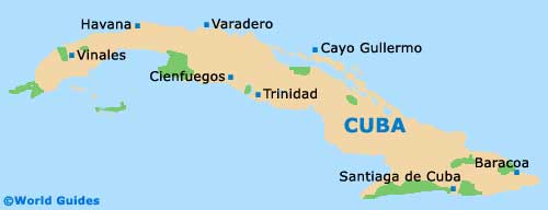
Map of Cuba
Map of Baracoa