Cienfuegos Maps and Orientation
(Cienfuegos, Cuba)
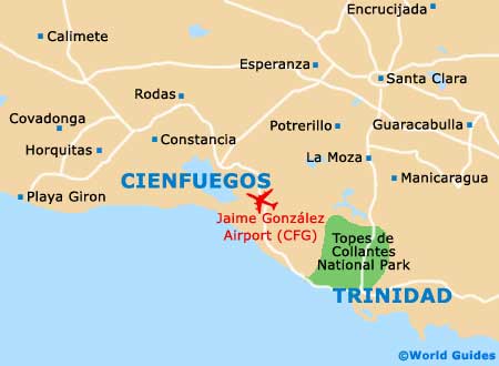
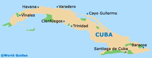
Cienfuegos is located roughly in the centre / south of
Cuba, lying about 250 km / 155 miles south-east of
Havana and to the south-west of Santa Clara. The city resides on the edge of a large lagoon, although is a fair way from the nearest beach, which is on the coast to the south.
The city is unofficially divided into two main areas on maps, with the downtown area being one, and Reparto Punta Gorda (further south) the other. Most of the interest is contained within Cienfuegos city centre, which comes with French colonial buildings, shopping streets and hotels.
Maps and Orientation of the City
The Paseo del Prado is the main street and connects the two parts of town, with Punta Gorda residing down at the water's edge. It is also known as Calle 37 and has the main shopping street of El Bulevar (the Boulevard) going west off it. This is a pedestrianised street full of shops, eateries and hotels and leads to the Parque Jose Marti.
Punta Gorda is the newer section, with most residing on the seafront - the part called the Malecón (meaning boardwalk). The entire city is on a grid pattern and has avenues (avenidas going west to east) and streets (calles) going north-south. Maps are good for a back-up and can be obtained from any good hotel lobby, or from the tourist information centre, though chronological numbering of the streets makes Cienfuegos easy to negotiate.
- Havana - 256 km / 159 miles (five hours, north-west)
- Playa Giron - 78 km / 48 miles (one hour and 35 minutes, west)
- Sancti Spiritus (via Santa Clara) - 135 km / 84 miles (three hours and 15 minutes, east)
- Santa Clara - 67 km / 42 miles (one hour and 15 minutes, north-east)
- Topes de Collantes - 82 km / 51 miles (two hours and 20 minutes, south-east)
- Trinidad - 70 km / 43 miles (two hours and 10 minutes, south-east)
Map of Cuba
Map of Cienfuegos