Natal Maps and Orientation
(Natal, Rio Grande do Norte, Brazil)
Located on the north-eastern side of
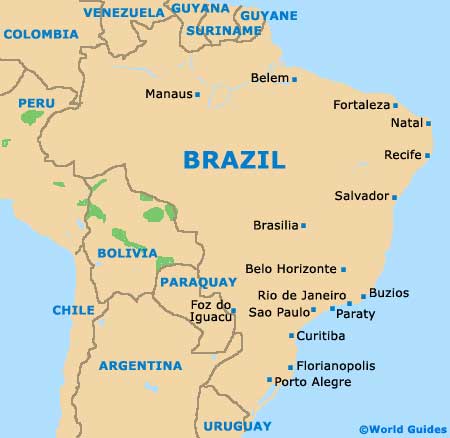
Brazil and next to the Atlantic Ocean coastline, Natal resides within the state of Rio Grande do Norte, where it is both the capital city and also the biggest city. Natal is now home to a population numbering more than 800,000 people, while the metropolitan area known as Greater Natal has a population of just under 1.3 million.
The Coastal Highway (Via Costeira) is one of the most important roads in the city and is also referred to as the Senador Dinarte Mariz Avenue. Stretching for around 10 km / 6 miles, this road is heavily used by tourists and connects the southerly Praia de Ponta Negra (Ponta Negra Beach) with the northern Praia do Meio (Meio Beach).
Maps and Orientation of the City
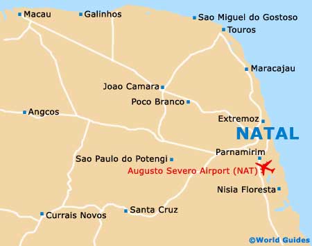
The most historic part of Natal enjoys a scenic peninsula setting, being edged by the Potengi River (west) and the Atlantic beaches (east). A useful landmark here is the Forte dos Reis Magos, which rather dominates the very northern tip of the peninsula.
The city centre (Cidade Alta) has grown up around the river port and dates back to the latter part of the 19th century. If you are looking for maps of Natal, then be aware the bookstores are not easy to come by. The simplest place to find maps is at the Augusto Severo International Airport, as well as the tourist outlets on the Avenida Erivan Franca, the Avenida Presidente Cafe Filho and the Rua Aderbal de Figueiredo.
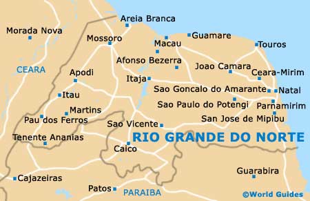
- Canguaretama - 77 km / 48 miles (one hour and 30 minutes, south)
- Ceara Mirim - 33 km / 21 miles (45 minutes, north-west)
- Extremoz - 22 km / 14 miles (30 minutes, north-west)
- Goianinha - 59 km / 37 miles (one hour and 15 minutes, south)
- Joao Camara - 80 km / 50 miles (one hour and 30 minutes, north-west)
- Macaiba - 20 km / 12 miles (30 minutes, south-west)
- Nisia Floresta - 40 km / 25 miles (55 minutes, south)
- Parnamirim - 17 km / 11 miles (25 minutes, south)
- Poco Branco - 62 km / 39 miles (one hour and 15 minutes, north-west)
- Santa Cruz - 119 km / 74 miles (two hours and 15 minutes, south-west)
- Sao José de Mipibu - 37 km / 23 miles (50 minutes, south)
- Sao José do Campestre - 106 km / 66 miles (one hour and 45 minutes, south-west)
- Sao Miguel do Gostoso - 108 km / 67 miles (one hour and 45 minutes, north-west)
- Sao Paulo do Potengi - 72 km / 45 miles (one hour and 25 minutes, west)
- Sao Tomé - 107 km / 66 miles (one hour and 45 minutes, west)
- Taipu - 53 km / 33 miles (one hour and ten minutes, north-west)
- Touros - 85 km / 53 miles (one hour and 35 minutes, north)
Map of Brazil
Map of Rio Grande do Norte
Map of Natal