Newport Maps and Orientation
(Newport, Gwent, South Wales, UK)
A fairly flat city with only a few hilly regions, Newport has a population of around 14,000 people and a number of inner suburbs, although if you include the urban area, the population is more like 165,000. Located close to the south-easterly coast of Wales, Newport is especially close to England, being linked by the M4 and M48 motorway, both of which cross the Severn Estuary and join the M5 motorways, heading towards
Bristol.
Lying alongside the meandering River Usk, Newport boasts a number of appealing waterfront areas in a spreading city, with its many suburban districts extending outwards along the numerous surrounding roads. This has resulted in a number of out-of-town shopping developments being created in these areas, which are gaining popularity and stand alongside large and modern housing estates.
To the south-west of Newport, the city of
Cardiff lies off the M4 motorway and is easy to reach. Other prominent locations nearby Newport include Cwmbran and Pontypool to the north, Monmouth to the north-east, Merthyr Tydfil and Tredegar to the north-west, and both Caerphilly and Pontypridd directly to the west.
Maps and Orientation of the City
Around Newport itself, the city is split into 20 different wards and parishes. Here are the wards in Newport, complete with population:
- Allt-yr-yn - (8,700)
- Alway - (8,600)
- Beechwood - (7,700)
- Bettws - (8,300)
- Caerleon - (8,800)
- Gaer - (8,700)
- Graig - (5,600)
- Langstone - (3,900)
- Llanwern - (3,200)
- Liswerry - (10,800)
- Malpas - (8,300)
- Marshfield - (4,400)
- Pillgwenlly - (5,500)
- Ringland - (8,600)
- Rogerstone - (8,900)
- Shaftesbury - (5,600)
- St. Julian's - (8,900)
- Stow Hill - (4,700)
- Tredegar Park - (3,600)
- Victoria - (6,800)
Map of the United Kingdom

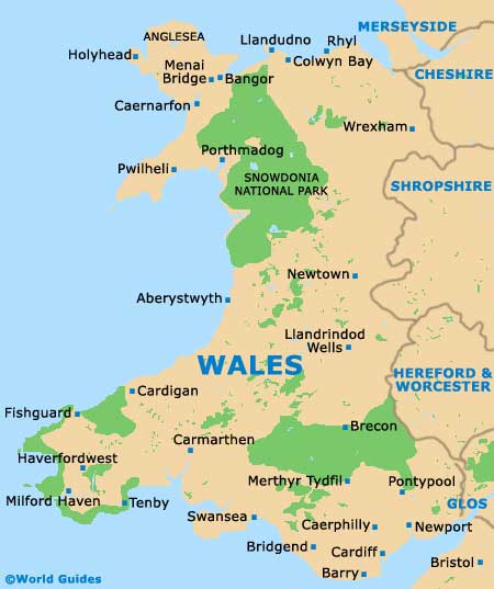
Map of Wales
Map of Newport

