Girona Maps and Orientation
(Girona, Catalonia, Spain)
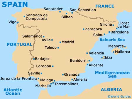
The ancient city of Girona lies on the far eastern side of Spain, within the autonomous community of Catalonia and close to the coastline of the Balearic Sea. Girona sits at the very point where no less than four different rivers converge, namely the Galligants, the Guell, the Onyar and the Ter rivers.
Capital of the Girona province and one of the principal cities in Catalonia, the city is roughly 100 km / 62 miles away from
Barcelona and serves as the home for a population of around 100,000 people.
Good maps of the city will clearly show the location of the southerly Girona-Costa Brava Airport, as well as other significant local landmarks, such as the Hospital de Santa Caterina (Gran Via de Jaume 1), the Main Post Office (near the Placa de la Independencia) and the Tourist Office (Rambla de la Llibertat).
Maps and Orientation of the City
The medieval streets found around the uphill Old Town of Girona are packed with historic character and overlook the easterly banks of the Onyar River below. Taking a stroll around the Old Town is most certainly recommended and this part of the city really is best explored in this manner.
The New Town stands across the river and is connected by a series of different bridges, while the railway station sits on the Placa d'Espanya and within close proximity to the Carrer de Barcelona. Those in need of bus transport will find that Girona's bus station is conveniently located close by, on the Carrer de Rafael Maso i Valenti.
- Banyoles - 21 km / 13 miles (25 minutes, north)
- Bescano - 8 km / 5 miles (15 minutes, west)
- Blanes - 43 km / 27 miles (55 minutes, south-east)
- Blanes - 43 km / 27 miles (55 minutes, south)
- Bonmati - 14 km / 9 miles (20 minutes, west)
- Cassa de la Selva - 13 km / 8 miles (20 minutes, south)
- Celra - 10 km / 6 miles (18 minutes, north-east)
- Figueres - 42 km / 26 miles (50 minutes, north)
- Fornells de la Selva - 6 km / 4 miles (12 minutes, south)
- La Bisbal - 27 km / 17 miles (35 minutes, east)
- Llagostera - 21 km / 13 miles (25 minutes, south)
- Lloret de Mar - 40 km / 25 miles (50 minutes, south)
- Medinya - 15 km / 9 miles (20 minutes, north-east)
- Palafrugell - 46 km / 29 miles (55 minutes, east)
- Palamos - 45 km / 28 miles (55 minutes, southeast)
- Salt - 3 km / 2 miles (eight minutes, west)
- Sant Feliu de Guixols - 33 km / 21 miles (40 minutes, south-east)
- Sant Mateu de Montnegre - 12 km / 7 miles (18 minutes, east)
- Santa Coloma de Farners - 27 km / 17 miles (35 minutes, south-west)
- Torroella de Montgri - 38 km / 24 miles (45 minutes, east)
- Tossa de Mar - 38 km / 24 miles (45 minutes, south)
Map of Spain

Map of Girona
