Stirling Maps and Orientation
(Stirling, Scotland, UK)
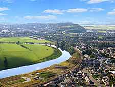
Stirling is famous as the 'Gateway to the Highlands', occupying the junction between the flatter undulating Lowlands and the rugged hills of the Highlands. Just north-west of the city one can see the first mountains of the Highlands, such as Ben Ledi and Ben Vorlich. Turn to the east and west of the city and the flat agricultural expanse of the Carse of Stirling spreads out to the horizon.
The city itself grew up around an ancient stone hill, where
Stirling Castle has held sway for centuries. This prime defensive position is at the lowest crossing point of the Forth River, and so it was always destined to be an important settlement. Stirling sits right on the Forth River, where it begins to turn tidal. Just to the east of the city one can see Abbey Craig, with its unmistakable 67-metre / 220-foot high Wallace National Monument.
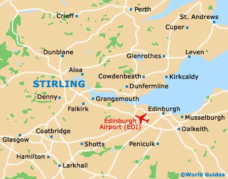
Maps and Orientation of the City
At the heart of Stirling lies the castle, which is visible from most parts of the city. The 'Top of the Town' is the district covered by Broad Street, Lower Castle Road, St. Mary's Walk, Castle Wynd and Ballengeich Pass. All of these streets lead up to Stirling Castle and are the hub of tourist wanderings, since many of the city's prime attractions are here.
From Broad Street up you will be walking on cobblestones, and there are several nice vantage points over the city on the way to the top. Being such a popular tourist destination, good city maps are easy to come by, being available at the Tourist Office on Dumbarton Road and for sale at local bookstores such as Waterstones at the Thistles shopping centre.
Surrounding Stirling are a number of interesting towns and natural attractions. The grand Firth of Forth is just to the east, with
Edinburgh a little further down the road.
Glasgow is not far away either, just to the south via the M80. To the west of Stirling is the expansive Queen Elizabeth Forest Park, Loch Lomond and Argyll Forest Park. A few minutes north lie the pleasant hamlets of Dunblane, Doune and
Callander.
- Aberdeen - 196 km / 122 miles (three hours, north-east)
- Aberdour - 55 km / 34 miles (one hour, east)
- Balquhidder - 47 km / 29 miles (50 minutes, north-west)
- Blairgowrie - 79 km / 49 miles (one hour and 20 minutes, north-east)
- Bonnybridge - 21 km / 13 miles (25 minutes, south)
- Callander - 25 km / 16 miles (25 minutes, north-west)
- Clackmannan - 18 km / 11 miles (20 minutes, east)
- Crianlarich - 72 km / 45 miles (one hour and ten minutes, north-west)
- Crieff - 37 km / 23 miles (40 minutes, north)
- Denny - 13 km / 8 miles (15 minutes, south)
- Dollar - 16 km / 10 miles (20 minutes, east)
- Doune - 13 km / 8 miles (15 minutes, north-west)
- Dunblane - 10 km / 6 miles (15 minutes, north)
- Dundee - 90 km / 56 miles (one hour and 20 minutes, north-east)
- Dunfermline - 37 km / 23 miles (40 minutes, east)
- Edinburgh - 56 km / 37 miles (one hour, south-east)
- Falkirk - 16 km / 10 miles (20 minutes, south-east)
- Falkland - 55 km / 34 miles (one hour, north-east)
- Fife - 72 km / 45 miles (one hour and ten minutes, east)
- Galashiels - 111 km / 69 miles (one hour and 30 minutes, south-east)
- Glasgow - 45 km / 28 miles (50 minutes, south-west)
- Inverness - 233 km / 145 miles (two hours and 45 minutes, north)
- Kinross - 39 km / 24 miles (45 minutes, north-east)
- Kirkcaldy - 72 km / 45 miles (one hour and ten minutes, east)
- Lanark - 68 km / 42 miles (one hour and 15 minutes, south)
- Larkhall - 53 km / 33 miles (one hour, south)
- Loch Achray - 39 km / 24 miles (45 minutes, north-west)
- Loch Katrine - 72 km / 45 miles (one hour and ten minutes, north-east)
- Loch Leven - 40 km / 25 miles (45 minutes, north-east)
- Loch Lomond - 47 km / 29 miles (55 minutes, west)
- Melrose - 116 km / 72 miles (one hour and 35 minutes, south-east)
- Perth - 53 km / 33 miles (one hour, north-east)
- St. Andrews Golf Course - 82 km / 51 miles (one hour and 20 minutes, north-east)
- Strathaven - 58 km / 36 miles (one hour and five minutes, south)
- Strathearn - 24 km / 15 miles (30 minutes, west)
- Tyndrum - 80 km / 50 miles (one hour and 20 minutes, north-west)
Map of the United Kingdom

Map of Scotland
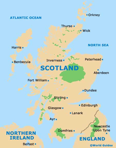
Map of Stirling