Lake Wanaka
(Wanaka, Otago, South Island, New Zealand)
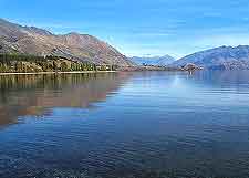
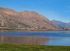
Situated within New Zealand's southerly Otago region and standing at an overall altitude of approximately 300 metres / 985 feet, Lake Wanaka is the country's fourth-biggest lake. Covering around 190 square kilometres / 73 square miles in total, Lake Wanaka is known to be more than 250 metres / 820 feet deep in places, over 42 km / 26 miles long, up to 10 km / 6 miles wide, and also goes by the name of simply 'Maori'.
Lake Wanaka occupies a scenic glacier valley, created over 10,000 years ago during the period of the ice age. The westerly shoreline is bounded by many tall mountains, while to the east there is also a series of peaks, although these are considerably lower and less prominent.
Tourism and General Information
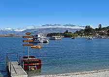
The township of Wanaka resides on the lake's southerly shore and just below Beacon Point. A number of small islands are situated within the southern region of the lake and the most noteworthy of these are Harwich Island, Rabbit Island and also Stevensons Island, all of which have become important nature reserves and sanctuaries.
Increasing levels of tourists have seen Lake Wanaka being something of a leading resort destination and during the summer months, visitors flock here to boat, fish, swim and enjoy an exciting jet-boat ride.
Neighbouring mountains and rivers also offer white-water rafting and other outdoor activities.
The shoreline of Lake Wanaka remains completely natural and undeveloped, and this is certainly very much part of its charm and overall appeal. Walking and hiking (tramping) trails surround much of the shore and enjoy many wonderful vantage points along the way. Popular walking and picnicking spots are to be found around Bremner Bay and Eely Point in particular.