Borobudur Maps and Orientation
(Borobudur, Central Java, Indonesia)
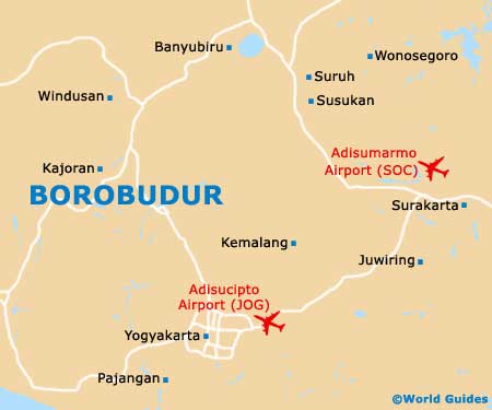
Enjoying a fairly central setting on the island of Java, Borobudur is especially close to
Yogyakarta and
Solo (Surakarta), and lies directly to the south of
Semarang. Borobudur itself is a small and very busy village, with a thriving tourist industry.
Each year, literally thousands of visitors come here to marvel at the magnificent Mahayana Buddhist Monument that is the Borobudur Temple. Magelang and Yogyakarta are the closest cities to the temple and are really just a short drive away.
Maps and Orientation of the Area
In the temple you will find a useful information office, where official guides and maps of the area are available. There is also a BNI cashpoint machine (ATM) located close to the entrance of Borobudur Temple, should you need to withdraw some holiday cash.
- Bandung - 370 km / 230 miles (six hours and 30 minutes, north-west)
- Banyubiru - 53 km / 33 miles (one hour, north-east)
- Bruno - 35 km / 22 miles (45 minutes, west)
- Dlingo - 50 km / 31 miles (one hour, south-east)
- Jakarta - 523 km / 325 miles (eight hours, north-west)
- Jumo - 56 km / 35 miles (one hour and five minutes, north)
- Kandangan - 35 km / 22 miles (45 minutes, north)
- Kemalang - 33 km / 21 miles (45 minutes, east)
- Magelang - 18 km / 10 miles (25 minutes, north)
- Nanggulan - 26 km / 16 miles (35 minutes, south)
- Pajangan - 55 km / 34 miles (one hour and five minutes, south)
- Pegandon - 110 km / 68 miles (two hours and ten minutes, north)
- Punggelan - 113 km / 70 miles (two hours and five minutes, north-west)
- Semarang - 94 km / 58 miles (one hour and 45 minutes, north)
- Solo (Surakarta) - 90 km / 56 miles (one hour and 45 minutes, east)
- Susukan - 80 km / 50 miles (one hour and 30 minutes, north-east)
- Windusari - 20 km / 12 miles (30 minutes, north)
- Wonosobo - 79 km / 49 miles (one hour and 30 minutes, north-west)
- Yogyakarta - 41 km / 25 miles (50 minutes, south-east)
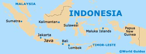
Map of Indonesia
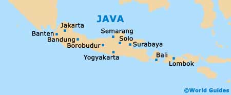
Map of Java
Map of Borobudur