Niagara on the Lake Maps and Orientation
(Niagara on the Lake, Ontario - ON, Canada)
Without question one of the prettiest and more appealing resorts within the whole of the Canadian province of Ontario, the town of Niagara on the Lake lies alongside both Lake Ontario and the Niagara River, which meet here. Located on the southerly side of Ontario, Niagara on the Lake is situated across the actual river from the American state of
New York, and the village of Youngstown, which has become well known for its annual sailing regattas.
Of course, most tourists staying in this town pay a visit to the nearby Niagara Falls, which are famous the world over and each day attracts crowds of thousands. Those headed for this legendary waterfall won't have fall to go, since it is a mere 26 km / 16 miles from the town centre and to the south.
Maps and Orientation of the Town
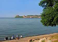
The town of Niagara on the Lake is particularly elegant and boasts neat tree-lined avenues and many historical buildings, dating from the early part of the 19th century. Lake Ontario dominates the northern side of town, while the eastern side is bounded by the Niagara River, which heads southwards to the falls.
Places of interest close by include the Memorial Park, on the southern side of the town, Fort George to the east, and the Fort Niagara State Park, which is sited across the river and close to Youngstown. Maps of the region are readily available at the Visitors Information Center, which can be found on Queen Street, within the Court House. Much of the area's tourism scene is concentrated within nearby Virgil, to the south-west, which is considered to be a suburb, along with Glendale, Homer and Queenston.
- Brantford - 125 km / 78 miles (one hour and 30 minutes, west)
- Buffalo (New York, USA) - 58 km / 36 miles (50 minutes, south)
- Burlington - 77 km / 48 miles (one hour, west)
- Fort Erie - 52 km / 32 miles (55 minutes, south)
- Grimsby - 54 km / 34 miles (45 minutes, west)
- Hamilton - 88 km / 55 miles (one hour and five minutes, west)
- Kitchener - 143 km / 89 miles (one hour and 55 minutes, north-west)
- Lockport (New York, USA) - 51 km / 32 miles (50 minutes, east)
- Mississauga - 113 km / 70 miles (one hour and 25 minutes, north-west)
- New York (New York, USA) - 681 km / 423 miles (seven hours and 15 minutes, east)
- Niagara Falls - 26 km / 16 miles (30 minutes, south)
- Oakville - 96 km / 60 miles (one hour and ten minutes, north-west)
- Queenston - 10 km / 6 miles (15 minutes, south)
- Rochester - 163 km / 102 miles (one hour and 50 minutes, east)
- St. Catharines - 20 km / 12 miles (25 minutes, west)
- Stoney Creek - 60 km / 37 miles (50 minutes, west)
- Stratford - 184 km / 114 miles (two hours and 30 minutes, west)
- Syracuse (New York, USA) - 285 km / 177 miles ( minutes, east)
- Thorold - 22 km / 14 miles (30 minutes, west)
- Tonawanda (New York, USA) - 48 km / 30 miles (50 minutes, south)
- Toronto - 132 km / 82 miles (one hour and 35 minutes, north)
- Virgil - 7 km / 4 miles (ten minutes, south-west)
- Waterloo - 146 km / 91 miles ( minutes, north-west)
Map of Canada

Map of Ontario

Map of Niagara on the Lake

