Niagara Falls Maps and Orientation
(Niagara Falls, Ontario - ON, Canada)
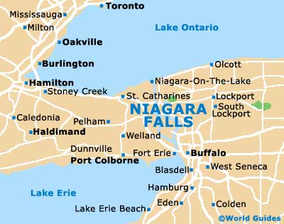
The Canadian city of Niagara Falls is to be found on the southerly side of Ontario and is a mere 80 miles / 130 km to the south-east of Toronto. Being so close to the world-famous waterfalls (Horseshoe and American), Niagara Falls has understandably become something of a vacation destination and is interestingly much favoured by honeymooners.
This city has grown up around the tourism of the falls themselves and has evolved with visitors in mind, with the main tourist district being based around the Niagara River Parkway. Here you will find many attractions, high-rise accommodation and a number of glitzy casinos.
Maps and Orientation of the City
Those holidaying in this part of Canada will find that there is much to see in Ontario. A popular day trip destination is the charming town of
Niagara on the Lake, which is situated some 16 miles / 26 km to the north and next to Lake Ontario.
Tourists preferring to explore the city itself will find maps and leaflets available at the Table Rock Center next to the Horseshoe Falls, and at tourism outlets along Stanley Avenue, close to the intersection with Roberts Street and Kitchener Street.
Map of Canada

Map of Ontario

Map of Niagara Falls