Maracaibo Maps and Orientation
(Maracaibo, Zulia, Venezuela)
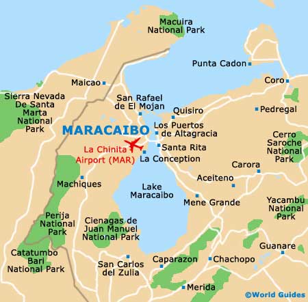
Maracaibo resides up in north-western Venezuelan, on the shores of
Lake Maracaibo, just over 500 km / 311 miles west of
Caracas. This is Venezuela's second-largest city, after Caracas, stretching for about 10 km / 6 miles east-west from the western shore of the lake.
The city is served by the huge General Rafael Urdaneta Bridge, which is a fair way south of downtown, yet still within the city. Downtown Maracaibo is quite compact, although having maps is a must for getting about, as it is easy to get disoriented.
Maps and Orientation of the City
Maracaibo is not your typical Venezuelan city, since it boasts an especially well turned out downtown area, almost to the point of being sterile. There are several pretty parks and self-contained colonial areas, all of which can easily be explored with maps. The lake is off to the east, while the airport is to the south-west and Bolivar Square is right in the centre. Off to the north are most of the top hotels, shops and restaurants.
Be sure to try and pre-book Maracaibo maps online before travelling. If you miss out, then the Corpozulia and Corzutur tourist information outlets offer maps for a small fee, while those staying in the swankier hotels can find them available at reception. If you find yourself lost even if you have a map, don't be tempted to hail a taxi unless absolutely necessary, as most of them on the road are unlicensed. It is therefore best to charter from a taxi rank.
- Cabimas - 50 km / 31 miles (one hour and five minutes, south-east)
- Caracas - 520 km / 322 miles (six hours, east)
- Hato Viejo - 24 km / 15 miles (30 minutes, south-west)
- La Vaca - 26 km / 16 miles (30 minutes, north-west)
- Merida - 225 km / 139 miles (two hours and 45 minutes, south)
- Oriental Coast - 50 km / 31 miles (one hour and ten minutes, south-east)
- Punto Fijo - 261 km / 162 miles (four hours, north-east)
- San Carlos del Zulia - 240 km / 149 miles (three hours, south)
- San Carlos Island - 45 km / 28 miles (55 minutes, north)
- San Rafael de El Mojan - 39 km / 24 miles (50 minutes, north)
- Santa Cruz de Maria - 35 km / 22 miles (45 minutes, north-west)
- Tamare - 28 km / 17 miles (35 minutes, north-west)
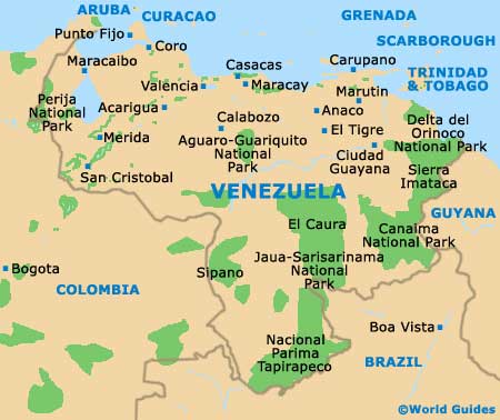
Map of Venezuela
Map of Maracaibo