Vinales Maps and Orientation
(Vinales, Pinar del Rio, Cuba)
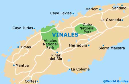
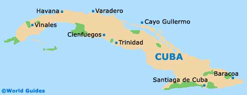
Vinales is located on the far western side of
Cuba, around 40 km / 25 miles north of Pinar del Rio, the principal city in the region. This is the main tobacco-growing area in Cuba, so most of the surrounding countryside is made up of farms and other agricultural sites. Vinales is located within the Pinar del Rio province, which is dominated by the low mountain ranges of the Cordillera Guaniguanico and interspersed with small fertile valleys.
Decent maps of the Vinales Valley can be found at most lodging options in the area. This is a prime region for bicycling, horseback riding and walking, and so there are many trails leading out of town into the surrounding countryside. The town also backs right onto the large Vinales National Park to the west. Here, you can get a guided tour to dozens of spectacular natural sites.
Maps and Orientation of the Town
The town is dominated by its central plaza. There is a single main street, the Calle Salvador Cisneros, which runs the length of the town and is flanked by another equally developed street, the parallel Calle Rafael Trejo. Most of the town's businesses are located along these two streets and the side lanes that shoot off of them.
Taxis congregate around the plaza, providing the main form of local transportation in town. They can be hired by the hour if you want to do some sightseeing in the valley. The Vinales Bus Tour is another convenient way to move about the town and valley, thanks to its 18 bus stops. Vinales and its valley are quite flat, and so many tourists simply rent a bicycle and explore the sights on their own, using a map obtained from one of the inns.
- Cabo San Antonio - 197 km / 123 mile (two hours, east)
- Cayo Jutias - 60 km / 37 miles (one hour and ten minutes, north)
- Cayo Levisa - 60 km / 37 miles (one hour and ten minutes, south-west)
- Havana - 200 km / 124 miles (two hours and 15 minutes, north-east)
- Maria la Gorda - 178 km / 112 miles (two hours, south-west)
- Pinar del Rio - 26 km / 16 miles (20 minutes, south)
- Vinales National Park - 2 km / 1 mile (five minutes, west)
Map of Cuba
Map of Vinales