Puerto Limon Maps and Orientation
(Puerto Limon, Limon, Costa Rica)
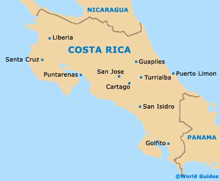
Puerto Limon, usually known as just Limon, is located on Costa Rica's Caribbean coastline, mostly in the lowland area. The northern border of the province abuts Nicaragua, its south-western side is mountainous, and its southern boundary is with Panama.
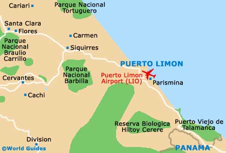
The provincial capital city, Puerto Limon lies on the coastal plains towards the southern border, backed by the foothills of the Cordillera de Talamanca mountains. Around the city, the countryside is given over to agriculture, with various fruits being the main crop and exported in large quantities through the port.
Maps and Orientation of the City
The city has two port terminals, Moin and Puerto Limon, with beaches spreading out to either side. It is divided into four main districts which in turn contain a number of neighbourhoods, suburbs and villages, and includes the older colonial part of town, the original settlement. Back from the coast is an easily negotiated grid of streets lined with dilapidated buildings and parks.
Urban renewal projects are underway, at present involving the main pedestrianised thoroughfare, the Puerto Limon Boulevard, which leads down to the harbour. City maps can be obtained from resorts and hotels, or downloaded at the Internet cafe located in the Terminal Caribeno bus station.
- Alajuela - 161 km / 100 miles (two hours and ten minutes, north-west )
- Barrabca - 185 km / 115 miles (two hours and 30 minutes, west)
- Bomba - 14 km / 9 miles (15 minutes, south)
- Cahuita - 102 km / 64 miles (one hour and 20 minutes, south-east)
- Flores - 103 km / 64 miles (one hour and 20 minutes, north-west)
- Paraiso - 124 km / 77 miles (one hour and 50 minutes, south-west)
- Parismina - 80 km / 50 miles (one hour and ten minutes, north-west)
- Parque Nacional Tortuguero - 85 km / 53 miles (one hour and ten minutes, north-west)
- Puerto Viejo de Talamanca - 63 km / 39 miles (one hour, south-east)
- Punterenas - 237 km / 148 miles (three hours and 15 minutes, south)
- San Jose - 168 km / 104 miles (two hours and 25 minutes, west)
- Santa Clara - 48 km / 30 miles (45 minutes, west)
- Siquirres - 58 km / 36 miles (55 minutes, west)
- Tortuguero - 95 km / 59 miles (one hour and 15 minutes, north-west)
Map of Costa Rica
Map of Puerto Limon