Izmir Maps and Orientation
(Izmir, Turkey)
A significant Turkish port city, Izmir lies next to the Aegean Sea and the Gulf of Izmir, and has long been the capital of the province with the same name. The city is currently home to more than two and a half million residents and is now Turkey's number three city in terms of overall population density.
Izmir is an extremely historical city and is actually one of the Mediterranean's oldest settlements, which is believed to date back more than 5,000 years. In 1922, the city suffered a devastating fire and lost many of its most significant buildings at this time, being dramatically restructured soon after.
Maps and Orientation of the City
The present day Greater Metropolitan area of Izmir is composed of a total of nine different neighbourhoods, as follows:
- Balcova - home to three large shopping malls and the thermal baths
- Bornova - where you will find the Forum Bornova shopping complex
- Buca - offering a range of attractions, such as the Yedi Göller (Seven Lakes) Park and the Dokuz Eylül University
- Cigli - situated next to the River Gediz
- Gaziemir - a busy industrial district in Izmir, with surrounding residential areas
- Güzelbahce - known for its seaside attractions and views of the Catalkaya mountain chain
- Karsiyaka - with the Karsiyaka Bazaar Street standing out as one of the main attractions, along with some historic mansions
- Konak - the site of Konak Square, at the southerly end of the Ataturk Caddesi
- Narlidere - following the southerly shoreline of the inner Gulf of Izmir
Other important towns and cities in Turkey, in relation to Izmir:
- Antalya - south-east
- Ankara - north-east
- Aydin - south-east
- Bergama - north
- Bodrum - south
- Cesme - west
- Istanbul - north
- Manisa - north-east
- Menemen - north
- Mugla - south-east
- Nazilli - south-east
- Odemis - east
- Salihli - east
- Selcuk - south
- Soke - south
- Soma - north-east
- Tire - south-east
- Turgutlu - east
- Urla - west
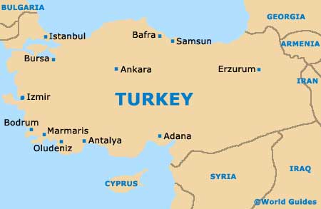
Map of Turkey
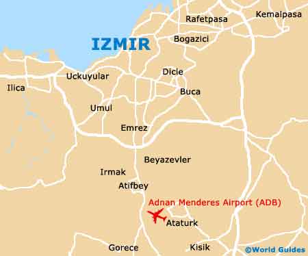
Map of Izmir