Gran Canaria Maps and Orientation
(Gran Canaria, Canary Islands, Spain)
After both
Tenerife and
Fuerteventura, Gran Canaria is the third-largest of all the Spanish Canaries, being followed by
Lanzarote, La Palma and La Gomera. This alluring Spanish archipelago can be found just a relatively short distance from Africa's north-westerly coast, being approximately 100 km / 62 miles west of the Western Sahara Desert border and to the south-west of the Moroccan capital,
Marrakech.
Home to a population now exceeding 800,000 people, Gran Canaria certainly has much to offer in the way of beaches and attractions.
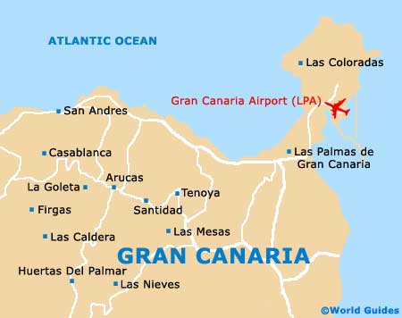
Las Palmas de Gran Canaria serves as the island capital and is very much centred around the neighbourhoods of both Triana and Vegueta.
Maps and Orientation of the City
Las Palmas is made up of a series of lengthy boulevards, which connect the harbourfront and Santa Catalina. For dining and nightlife, Vegueta proves a reliable option, while for hotels, the Santa Catalina areas comes with much accommodation, being within easy reach of the expansive Playa de las Canteras beach.
For maps of Gran Canaria, look out for the complimentary map sponsored by the famous Spanish department store, El Corte Inglés, which is widely available and easy to find at stores and the tourist offices. You may also like to look out for the Guaguas Municipales public transport maps, if you are intending to make use of the island buses.
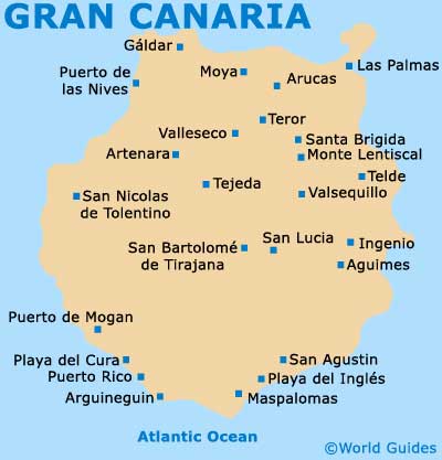
The following are distances and directions calculated from Las Palmas de Gran Canaria:
- Arguineguin - 65 km / 40 miles (one hour and 20 minutes, south-west)
- Artenara - 47 km / 29 miles (one hour and five minutes, south-west)
- Arucas - 13 km / 8 miles (18 minutes, west)
- Galdar - 25 km / 16 miles (30 minutes, west)
- Maspalomas - 56 km / 35 miles (one hour and 15 minutes, south-west)
- Monte Lentiscal - 15 km / 9 miles (20 minutes, south-west)
- Moya - 24 km / 15 miles (30 minutes, west)
- Puerto de las Nieves - 34 km / 21 miles (40 minutes, west)
- Puerto de Mogan - 83 km / 52 miles (one hour and 35 minutes, south-west)
- San Bartolome - 59 km / 37 miles (one hour and 15 minutes, south-west)
- San Nicolas de Tolentino - 70 km / 43 miles (one hour and 25 minutes, south-west)
- Santa Brigida - 18 km / 11 miles (25 minutes, south-west)
- Tejeda - 42 km / 26 miles (one hour, south-west)
- Telde - 20 km / 12 miles (25 minutes, south)
- Teror - 21 km / 13 miles (25 minutes, south-west)
- Valleseco - 28 km / 17 miles (35 minutes, south-west)
- Valsequillo - 29 km / 18 miles (35 minutes, south-west)
Map of the Canary Islands

Map of Gran Canaria