Moscow Maps and Orientation
(Moscow, Central Federal District, Russia)
The jewel of the Russian crown, Moscow is Russia's modern capital city and an important centre for finance and economy. Moscow is officially located within the Central Federal District of European Russia and currently features a total population of around 11 million residents.
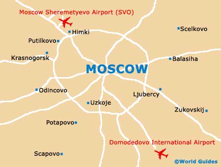
Situated on the banks of the River Moskva (Moscow River), the city is surrounded by five notable ring roads, which encircle the city and spread outwards from the actual centre itself. The Inner Ring Road can be found just a short distance to the north of the Kremlin building and alongside a number of public squares, such as both Teatralnaya and Manezhnaya. Further outside of central Moscow, the other roads are Boulevard Ring, the Garden Ring, the Third Ring and finally the Outer Ring Road, which is around 20 km / 12 miles from the Kremlin.
Maps and Orientation of the City
Central Moscow can be a little confusing to traverse and features many radial streets and roads, which head outwards and intersect the ring roads. A map is always useful and the Kremlin forms an important point of reference, lying in the very heart of Moscow. Red Square is sited on its easterly side and to the south, the Moscow River forms a natural boundary.
Much of the city is fairly flat, although the south-western Sparrow Hills are worthy of a mention, being home to the eye-catching Moscow University tower. This giant skyscraper forms one of the city's famous seven 'Stalinist' skyscrapers, which are often referred to as the 'Seven Sisters of Moscow'.
- Cehov - south
- Dmitrov - north
- Domodedovkiy Rayon - south
- Klimovsk - south
- Krasnogorsk - west
- Krasnogorskiy Rayon - west
- Leninskiy Rayon - south
- Likino Dulevo - east
- Lyuberetskiy Rayon - south
- Mytisci - north-east
- Naro-Fominsk - south-west
- Odincovo - west
- Odintsovkiy Rayon - west
- Orehovo Zuevo - east
- Podol'skiy Rayon - south
- Shchyolkovskiy Rayon - north-east
- Zelenograd - north-west
Map of Russia

Map of Moscow