Debrecen Maps and Orientation
(Debrecen, Hajdu-Bihar, Hungary)
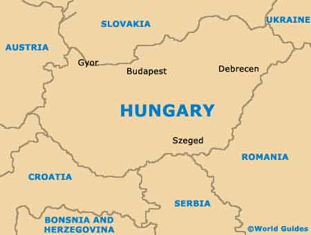
Situated on the Eastern Plain and on the far easterly extremes of
Hungary, Debrecen is a large and appealing city, with a population now exceeding 215,000 people. Currently Hungary's number two city after the Hungarian capital of
Budapest, Debrecen lies within the county of Hajdú-Bihar and is close to the Hortobagyi Nemzeti Park.
Debrecen is also nearby Romania, Slovakia and the Ukraine, and many people choose to visit these countries after spending time in this part of Hungary. Fast motorways now enable Debrecen to be easily reached from much of Hungary and connects
Budapest, which can be reached in around three hours.
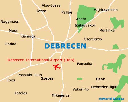
Maps and Orientation of the City
In general, Debrecen is an easy city to find your way around. The Inner Town area known as the Belváros is encompassed by a ring road, which is divided by the Piac Utca, a major thoroughfare running to the northerly railway station (Petofi Tér) and ultimately to the Kálvin Tér, in the heart of Debrecen city centre.
Situated on the Széchenyi Utca and in the area referred to as the 'Outer Marketplace' is Debrecen's bus station (Külso Vásártér). For maps of Debrecen, check out the bookshop along the Piac Utca, or pay a visit to the nearby Tourinform office.
- Békéscsaba - 127 km / 79 miles (two hours, south)
- Budapest - 230 km / 143 miles (three hours and 20 minutes, west)
- Bükki Nemzeti Park - 142 km / 88 miles (two hours and 20 minutes, north-west)
- Gyula - 122 km / 76 miles (two hours, south)
- Hajdúszoboszló - 22 km / 14 miles (30 minutes, south-west)
- Hortobagy Nemzeti Park - 55 km / 34 miles (one hour, west)
- Karcag - 66 km / 41 miles (one hour and five minutes, south-west)
- Kecskemét - 185 km / 115 miles (two hours and 40 minutes, south-west)
- Kisvárda - 99 km / 62 miles (one hour and 25 minutes, north)
- Kosice (Slovakia) - 190 km / 118 miles (two hours and 45 minutes, north)
- Miskolc - 113 km / 70 miles (one hour and 40 minutes, north-west)
- Nyiregyháza - 50 km / 31 miles (45 minutes, north)
- Oradea (Romania) - 71 km / 44 miles (one hour and ten minutes, south)
- Szeged - 219 km / 136 miles (three hours and 15 minutes, south-west)
- Szolnok - 132 km / 82 miles (two hours and five minutes, south-west)
- Tatabánya - 296 km / 184 miles (three hours and 45 minutes, west)
Map of Hungary
Map of Debrecen