Seychelles Maps and Orientation
(Seychelles, SC, Africa)
Officially named the Republic of Seychelles, this island country lies in the Indian Ocean and is roughly 1,500 km / 930 miles from
Kenya on mainland
Africa, which is located directly to the west. To the south-west is
Madagascar, while to the far north east are the Maldives.
The archipelago comprises two main regions, the Outer Seychelles and the Inner Seychelles. The Outer region is made up mainly of coral islands, often uninhabited and generally reached by yacht, although some do have small airstrips. Within the Outer Seychelles you will find the Aldabra Islands and the Amirante Islands, as well as the Alphonse Group, the Farquhar Group and also the Southern Coral Group.
Maps and Orientation of the Archipelago and Islands
The majority of the country's populated granite islands reside within the region known as the Inner Seychelles. Mahé is the biggest and close to the islands of Cerf, Mamelles and Sainte Anne. Praslin is another significant island and neighboured by the Aride, Curieuse and Cousin islands.
A number of small islands lie just off the shore of La Digue. These include Felicite, Fregate, Marie Anne, Recif and the Sisters islands. Further significant islands within the Inner Seychelles include Anonyme, Cachée, Cocos, Conception, Grande Soeur, Ile aux Vaches Marines, Long, Marianne, Moyenne, Petite Soeur, Round, St. Pierre, Silhouette, Thérèse and North Island, amongst others. Much visited by holiday makers are the Inner Corallines (Bird and Denis), which are well connected by boat trips and come with luxury beach resorts.
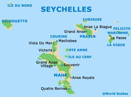
Islands Map of Seychelles
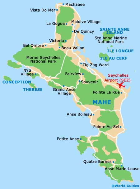
Map of Mahe