Maui Maps and Orientation
(Maui, Hawaii - HI, USA)
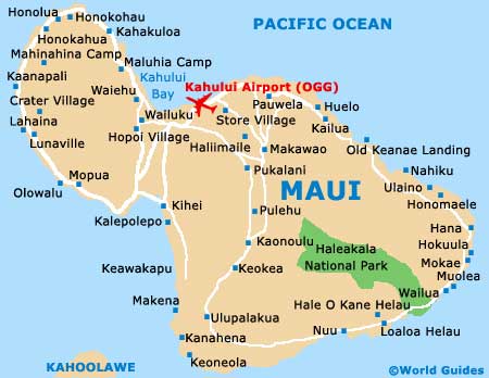
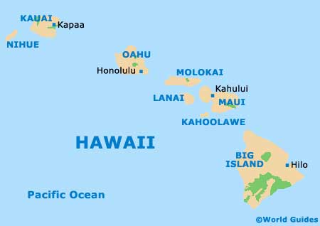
The sizeable Hawaiian island of Maui ranks as the second-biggest of all the eight principal islands that combine to make up the archipelago of Hawaii, after the
Big Island. Covering an area of approximately 729 square miles / 1,888 square kilometers, the island itself measures roughly 48 miles / 77 km at its longest point, by a maximum of 26 miles / 42 km in width.
Maui is an especially green island with many forested areas. On the eastern side of the island is the Halkakala National Park, the Hana Forest Reserve, the Hanawi Natural Forest Reserve, the Kahikinui Forest Reserve, the Kipahulu Forest Reserve and also the Koolau Forest Reserve, while the aptly named West Maui Forest Reserve lies to the west.
Tourists will find that West Maui is known for its luxury hotels, with many of the very best being based along the coastline of Lahaina. Notable beaches here include those of Kapalua and Kaanapali. Those based here will find that maps of the island can be obtained from the Lahaina Visitor Center at the Old Courthouse on Wharf Street.
Maps and Orientation of the City
Known for its superb windsurfing conditions, Maalaea Bay is another notable part of Maui, connecting the West Maui Mountains with Kihei Beach. Kihei and the southern shore feature literally miles of sandy coastline, with popular resorts along this stretch including both Makena and Wailea.
Kahului and Wailuku are the two most sizeable communities on Maui, being located alongside each other on the northern coast. Kahana Beach is a notable highlight here, although many holiday makers simply come to this part of the island for its airport. Roughly ten minutes to the east of Kahului Airport, Paia offers an interesting sugar plantation heritage and boasts superb waves for surfers.
Directions from the center of the island:
- Ahihi Kinau Natural Area Reserve (south)
- Haiku-Pauwela (north)
- Haleakala National Park (southeast)
- Hana Forest Reserve (southeast)
- Hanawi Natural Forest Reserve (east)
- Kahikinui Forest Reserve (south)
- Kahului (northwest)
- Kihei (southwest)
- Kipahula Forest Reserve (southeast)
- Koolau Forest Reserve (east)
- Kula Forest Reserve (south)
- Lahaina (west)
- Maalaea Bay (west)
- Makawao (north)
- Makawao Forest Reserve (east)
- Napili-Honokowai (northwest)
- Wailua (northeast)
- West Maui Forest Reserve (west)
Map of the United States

Map of the Hawaii Islands
Map of Maui