Little Rock Maps and Orientation
(Little Rock, Arkansas - AR, USA)
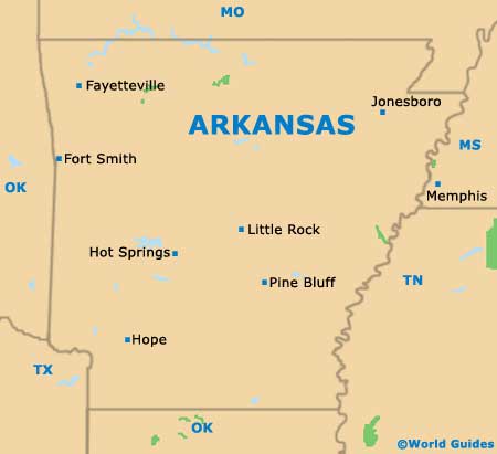
Sited next to the geographical heart of Arkansas and to the north of Pine Bluff, the city of Little Rock is the proud state capital. Little Rock is also the biggest city in the state of Arkanas and serves as the seat of Pulaski County.
The city is based on the southerly side of the Arkansas River, with the creeks of both Fourche and Rock meandering their way through central Little Rock. Providing an imposing backdrop, the Ouachita Mountains stand to the west, while the Pinnacle Mountain dominates the city's northwesterly outskirts, along with Lake Maumelle.
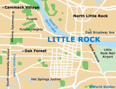
Tourists looking to familiarise themselves with the layout of Little Rock should grab a map and head to the River Market district, which is the perfect place for a stroll, being at its best around President Clinton Avenue and West Markham Street.
Maps and Orientation of the City
Based between South Rock Street and South Commerce Street, the Ottenheimer Market Hall is known in Little Rock for its array of stores and eateries. For more trendy shops and a noticeable cluster of cafes, head to the westerly Hillcrest neighborhood, or for a bite to eat with a waterfront view, pay a visit to the River Market.
For sightseers, downtown Little Rock is where many of the principal attractions reside. These include the Arkansas State Capitol, the Arkansas Studies Institute, the Central Arkansas Library, the Central High School National Historic Site and Museum, the Daisy Bates House, the Gazette Building, the Historic Arkansas Museum, MacArthur Park, the Old State House, the Riverfront Park, and the William J. Clinton Presidential Library and Park.
- Cammack Village - 5 miles / 8 km (ten minutes, northwest)
- East End - 20 miles / 32 km (35 minutes, south)
- Fort Smith - 159 miles / 256 km (three hours and 40 minutes, northwest)
- Gravel Ridge - 14 miles / 23 km (25 minutes, northeast)
- Hope - 113 miles / 182 km (two hours and 40 minutes, southwest)
- Hot Springs - 55 miles / 89 km (one hour and 25 minutes, west)
- Jonesboro - 132 miles / 212 km (three hours and ten minutes, northeast)
- Lake Maumelle - 22 miles / 35 km (40 minutes, northwest)
- Mayflower - 22 miles / 35 km (40 minutes, north)
- Parkers-Iron Springs - 13 miles / 21 km (20 minutes, south)
- Pine Bluff - 44 miles / 71 km (one hour and 15 minutes, south)
- Pinnacle Mountain State Park - 17 miles / 27 km (30 minutes, northwest)
- Shannon Hills - 15 miles / 24 km (25 minutes, southwest)
- Sherwood - 11 miles / 18 km (20 minutes, northeast)
- Wrightsville - 14 miles / 23 km (25 minutes, south)
Map of the United States

Map of Arkansas
Map of Little Rock