Puntarenas Maps and Orientation
(Puntarenas, Costa Rica)
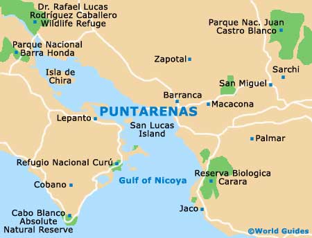
Puntarenas is located along a spoon-shaped 8-km / 5-mile peninsula, jutting out into the sea near the Nicoya peninsula on Costa Rica's Pacific coast. Cut off from the rest of the country until the mid-19th century by the peaks of the central mountains, the city's only access for most if its history was by sea. Nearby are a number of offshore islands, and the region contains wetlands, several national parks and an impressive selection of beaches.
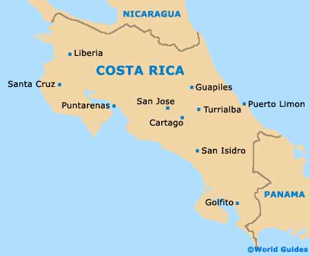
The narrow coastal plain contains banana plantations, while in the foothills, the delicious local coffee is commercially grown. Puntarenas is well-placed for trips to Costa Rica's capital of San Jose, and also to the eco-areas to the north and south. The city's port hosts cruise ships and runs a few ferries to nearby coastal destinations. Driving times from Puntarenas depend on the terrain, more than on the actual distance.
Costa Rica road maps can be found at San Jose's Juan Santamaria International Airport (SJO), at local tourist offices or online.
Maps and Orientation of the City
Navigating the streets of Puntarenas is straightforward due to the shape of the peninsula, with most calles (streets) running north to south, and the five east to west avenidas (avenues) heading lengthwise, parallel to the coast. Basically, Puntarenas is a long, very narrow town surrounded by beaches. At the centre is both the Parque Central and the cathedral.
Most visitor activity centres on the Avenida 4, known as the Paseo de los Turistas, a 2-km / 1.5-mile long coastal promenade home to most of the accommodation, restaurants, and souvenir stalls and shops. Visitors to Puntarenas should note that no part of the city is safe for walking after dark, especially in the areas around the Central Market (Mercado Central) and the western end of the peninsula. Maps of the city may be difficult to find on arrival, except in upscale hotels or at the tourism office situated opposite the pier, above the Bancredito.
- Alajuela - 90 km / 56 miles (one hour and 45 minutes, east)
- Dominical - 187 km / 116 miles (three hours and 15 minutes, south-east)
- Guanacaste - 132 km / 82 miles (two hours and 20 minutes, north-west)
- Jaco - 75 km / 47 miles (one hour and 25 minutes, south)
- Liberia - 132 km / 82 miles (two hours and 35 minutes, north-west)
- Manuel Antonio - 154 m / 96 miles (two hours and 50 minutes, south-east)
- Matapalo - 167 km / 104 miles (two hours and 55 minutes, west)
- Monteverde - 80 km / 50 miles (one hour and 35 minutes, north)
- Quepos - 140 km / 88 miles (two hours and 50 minutes, south-east)
- San Isidro del General - 185 km / 115 miles (three hours and 20 minutes, south-east)
- San Jose - 110 km / 68 miles (one hour and 50 minutes, east)
- Santa Cruz - 150 km / 93 miles (two hours and 50 minutes, north-west)
- Sarchi - 66 km / 41 miles (one hour, east)
- Uvita - 190 km / 118 miles (three hours and 25 minutes, south-east)
Map of Costa Rica
Map of Puntarenas