Istanbul Maps and Orientation
(Istanbul, Marmara, Turkey)
Forming the financial heart of Turkey and home to more than 11 million residents, Istanbul is an enormous city and lies along the Bosphorus Strait (Bosporus), which separates Europe and Asia. Istanbul is home to a large natural harbour, which has been named the Golden Horn and divides Turkey's Anatolia and Rumelia areas, linking the Sea of Marmara with the Black Sea.
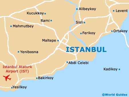
Situated within the north-westerly Turkish region of Marmara, Istanbul is comprised of no less than 27 individual districts. Sultanahmet forms the centre of Old Istanbul and is always a good place to begin exploring the city, being home to famous sights such as the
Blue Mosque, the Hagia Sophia and also the Topkapi Palace, amongst many other historical sights.
Maps and Orientation of the City
Lying along the Sultanahmet area, the Cankurtaran area contains a good choice of affordable hotels, while the boulevard known as the Divan Yolu leads towards Istanbul's famed
Grand Bazaar. Head to the north and you will soon come upon the Suleymaniye Mosque (Suleymaniye Camii), which enjoys a prominent hilltop setting. Close by, the Eminonu district has become a leading transport hub for Istanbul.
Across the Galata Bridge, Beyoglu is another popular part of Istanbul, where exceptional shops and nightlife opportunities await, particularly around Taksim Square. If you require a map of Istanbul, then simple city maps are available from all of the tourist information outlets, being free of charge and more than adequate for most travellers visiting this part of Turkey.
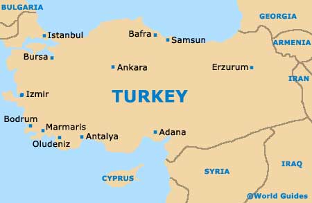
- Adapazari - south-east
- Ankara - south-east
- Bilecik - south
- Bolu - east
- Bursa - south
- Cankiri - south-east
- Edirne - north-west
- Eskisehir - south-east
- Gelibolu - west
- Gallipoli Peninsula - west
- Izmir - south-west
- Sile - east
- Troy (Truva) - south-west
- Uludag - south
- Zonguldak - east
Map of Turkey
Map of Istanbul