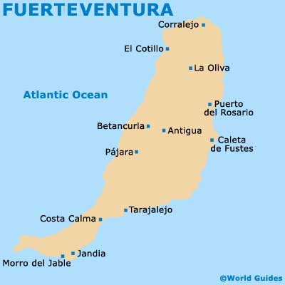
Fuerteventura Maps and Orientation
(Fuerteventura, Canary Islands, Spain)
The Spanish island of Fuerteventura is part of the Canary Islands (Las Islas Canarias), where it is the second-biggest of the Canaries, after only
Tenerife. Puerto del Rosario has long been the island capital and is really the only significant town on Fuerteventura that is not solely a tourist destination as such.
Located on the north-eastern coast of Fuerteventura, Puerto del Rosario has been the capital since 1860, being awarded this title thanks in no small part to its notable harbourside setting. This modern port town was previously known as Puerto de las Cabras.
Maps and Orientation of the City
The centre of Puerto del Rosario is within easy walking distance of the harbourfront, being connected by the Calle León y Castillo. Dissecting this street is the Avenida Primero de Mayo, which serves as something of a commercial zone.
Those in need of Fuerteventura maps should look out for the Guia de Comercios y Servicios de Puerto del Rosario (Local Business and Services Guide). Maps are in good supply within the tourist offices on the Avenida Constitución and at Fuerteventura Airport (FUE).
Useful distances and directions from Puerto del Rosario are as follows:
- Antigua - 21 km / 13 miles (30 minutes, south-west)
- Betancuria - 28 km / 17 miles (40 minutes, south-west)
- Caleta de Fustes - 12 km / 7 miles (15 minutes, south)
- Corralejo - 32 km / 20 miles (45 minutes, north)
- Costa Calma - 67 km / 42 miles (one hour and 15 minutes, south-west)
- El Cotillo - 38 km / 24 miles (50 minutes, north-west)
- Jandia - 71 km / 44 miles (one hour and 20 minutes, south-west)
- La Oliva - 24 km / 15 miles (30 minutes, north-west)
- Morro del Jable - 88 km / 55 miles (one hour and 30 minutes, south-west)
- Pajara - 40 km / 25 miles (50 minutes, south-west)
- Tarajalejo - 55 km / 34 miles (one hour and five minutes, south-west)
- Tuineje - 33 km / 21 miles (45 minutes, south-west)
Map of the Canary Islands

Map of Fuerteventura