Corsica Maps and Orientation
(Corsica, France)
Given that a hire car is the only practical means of transportation on Corsica, a good map showing the mountain roads, as well as the roads around the shoreline, is essential. Maps of the island can be downloaded from the Internet, and the many Corsican tourist offices can also provide detailed maps showing the main places of interest.
Corsica lies a few hours' boat ride to the west of the Italian mainland, with its southern tip on the same latitude as
Rome. The island itself is split in two by mountain ranges, with most roads skirting the coastline and only a few highways braving the mountains. The island of
Sardinia lies close to the southern tip of Corsica, in a south-westerly direction.
Maps and Orientation of the Island
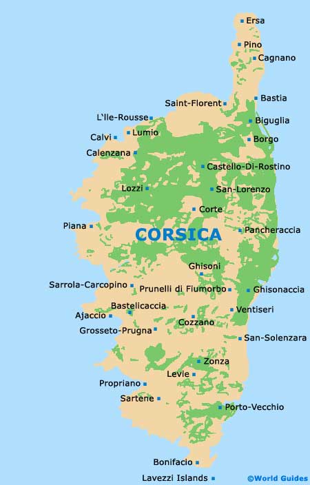
The main tourist destinations on Corsica are located in the south and north-east of the island, and boast easier access and better travel facilities than the rest of the island. Bonifacio and Porto Vecchio lie on the southern part of the island, with Bonifacio right on the southernmost point, facing nearby Sardinia and offering regular ferries to this Italian island. Calvi lies on the north-west coast and the island's capital, Ajaccio, lies towards the southern part of the island, also on the west coast.
Corsica is divided into two historic sections, l'En Deca des Monts and l'Au Dela des Monts, along its watershed in the central mountainous spine of the island. The line runs from north-west near Calvi to south-east near Bavella, and the valleys either side run north-east and south-west from the mountain chain. Valley systems are linked by mountain paths and mule tracks with steep gradients, and very few negotiable roads exist.
- Ajaccio to Bastia - 149 km / 93 miles (two hours and 20 minutes, north-west)
- Ajaccio to Bonifacio - 122 km / 76 miles (two hours, south)
- Ajaccio to Calvi - 154 km / 96 miles (two hours and 30 minutes, north)
- Ajaccio to Corte - 82 km / 51 miles (one hour and 20 minutes, north-west)
- Ajaccio to Cozzano - 60 km / 38 miles (one hour and 15 minutes, west)
- Ajaccio to Ghisonaccia - 103 km / 64 miles (one hour and 40 minutes, west)
- Ajaccio to Ghisoni - 77 km / 48 miles (one hour and 20 minutes, north-east)
- Ajaccio to Lozzi - 103 km / 64 miles (one hour and 40 minutes, north-east)
- Ajaccio to Piana - 68 km / 42 miles (one hour and 15 minutes, north)
- Ajaccio to Porto Vecchio - 126 km / 75 miles (two hours and 15 minutes, south-west)
- Ajaccio to Prunelli di Fiumorbo - 120 km / 75 miles (two hours, east)
Map of Corsica
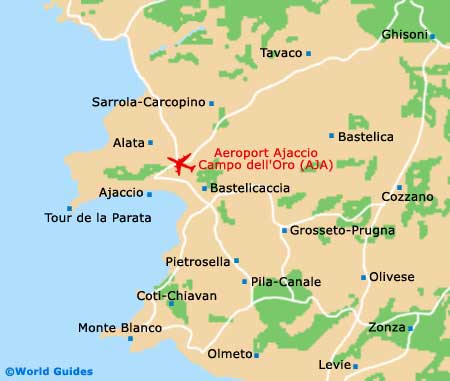
Map of Ajaccio Airport (AJA) Location
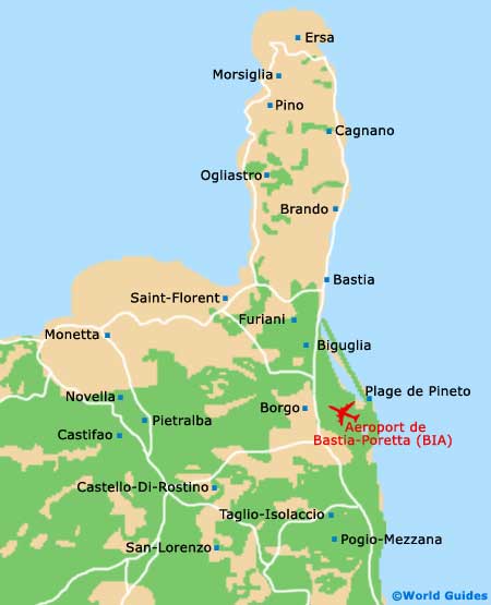
Map of Bastia Airport (BIA) Location